 Filter: Categories of Wisconsin Historical Images
Filter: Subject of Flowers
Filter: Subject of maps
Filter: Categories of Wisconsin Historical Images
Filter: Subject of Flowers
Filter: Subject of maps

| Date: | 1655 |
|---|---|
| Description: | Frontispiece to Newe Welt vnd americanische Historien (1655). |
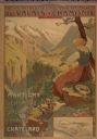
| Date: | 1900 |
|---|---|
| Description: | An original colored lithograph advertising the Chemins de Fer électrique du Valais à Chamonix (Electric Railways of Valais in Chamonix) railway. The poster... |
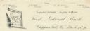
| Date: | |
|---|---|
| Description: | Numbered letterhead of the First National Bank, with a map of Wisconsin and a starred location marker for Chippewa Falls, a medallion, and a flowering stal... |
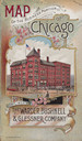
| Date: | 1893 |
|---|---|
| Description: | Front cover of a brochure for Champion Mowers and Binders. Features a color illustration of the office building of the Warder, Bushnell and Glessner Compan... |

| Date: | 1780 |
|---|---|
| Description: | This map portrays North and South America at a very unusual angle, with north oriented towards the upper right corner. Colonies, Native American land, a fe... |

| Date: | 1759 |
|---|---|
| Description: | Map of North and South America showing regions, colonies, cities and settlements, rivers, lakes, and Native American land. Near the bottom left an inset ma... |

| Date: | 1763 |
|---|---|
| Description: | Map of America and part of Canada including the borders of European claims after the French and Indian War. Cities, forts, Native American lands, rivers, l... |

| Date: | 1755 |
|---|---|
| Description: | Map of colonial America, showing the lands north of South Carolina and west of the Mississippi River. An inset map of the Carolinas and Georgia sits in the... |

| Date: | 1780 |
|---|---|
| Description: | Detailed map of America east of the Louisiana region. It shows forts, cities, borders and boundary lines, Native American land, the post road, mountains, w... |

| Date: | 1795 |
|---|---|
| Description: | Map of Connecticut showing counties, townships, cities, roads, islands, swamps, hills, mountains, lakes, rivers, reefs, and numerous other geographical and... |
If you didn't find the material you searched for, our Library Reference Staff can help.
Call our reference desk at 608-264-6535 or email us at: