 Filter: Categories of Wisconsin Historical Images
Filter: Subject of Ferries
Filter: Year of 1900-1999
Filter: Year of 1930-1939
Filter: Categories of Wisconsin Historical Images
Filter: Subject of Ferries
Filter: Year of 1900-1999
Filter: Year of 1930-1939
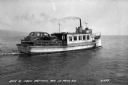
| Date: | 1938 |
|---|---|
| Description: | A car ferry transporting a car on Lake Superior between LaPointe, Madeline Island, and Bayfield. Two men are sitting on a bench near the car, and a shoreli... |
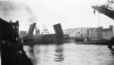
| Date: | 06 1939 |
|---|---|
| Description: | Bridge on the Manitowoc River raised to allow the Pere Marquette car ferry through. River dredging equipment can be seen in the foreground. |

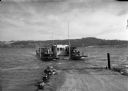
| Date: | 1938 |
|---|---|
| Description: | A man stands holding a rope on an auto ferry dock. The ferry was powered by an International P-12 power unit and provided transportation to Ridge Island. A... |

| Date: | 1930 |
|---|---|
| Description: | View toward pedestrians on a road between buildings leading to a ferry at the wharf in the harbor. |
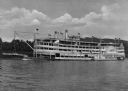
| Date: | 1930 |
|---|---|
| Description: | View of the steamship "Island Queen," near Coney Island, which is on the Ohio River near Cincinatti. "Island Queen Coney Island" is painted on the rear of ... |
| Date: | 1938 |
|---|---|
| Description: | View from road leading down to shoreline of a Mississippi River ferry bringing several cars across the river. |

| Date: | 1939 |
|---|---|
| Description: | This nine-part map from the U.S. Bureau of Public Roads identifies federal and state highways in Wisconsin by pavement type. County, forest, park, and publ... |

| Date: | 1933 |
|---|---|
| Description: | This map shows the major highways and freeways of Wisconsin as well as road surfaces, state parks, points of interest, ferry routes, bridges, and towns whe... |

| Date: | 1936 |
|---|---|
| Description: | This map shows road surfaces, construction, flying fields, seaplane landings, populations of cities and towns, and ferry routes of Wisconsin and some of th... |

| Date: | 1930 |
|---|---|
| Description: | This map shows the entire state plus portions of Illinois, Iowa, Minnesota, and Michigan outlined in blue. The map shows roads, state parks (black triangle... |

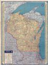
| Date: | 1934 |
|---|---|
| Description: | This road map contains automobile routes for the state of Wisconsin as well as portions of Minnesota, Illinois, Iowa and Michigan. Lake Michigan, Lake Sup... |

| Date: | 1935 |
|---|---|
| Description: | This colored road map comes with a map legend and explanation, as well as an index of cities and towns (and their populations) in Wisconsin. Information ab... |

| Date: | 1936 |
|---|---|
| Description: | This colored road map shows automobile roads in Wisconsin as well as portions of Michigan, Iowa, Minnesota, and Illinois. U.S. numbered highways are shown ... |

| Date: | 1936 |
|---|---|
| Description: | This colored road map shows automobile roads in Wisconsin as well as portions of nearby states. U.S. numbered highways are shown in red, and information ab... |

| Date: | 1936 |
|---|---|
| Description: | This colored road map shows automobile roads in Wisconsin as well as portions of nearby states. Information on the quality and type of any given road (pave... |

| Date: | 1936 |
|---|---|
| Description: | This colored road map shows automobile roads in Wisconsin as well as portions of nearby states. Information on the quality and type of any given road (pave... |

| Date: | 1936 |
|---|---|
| Description: | This colored road map shows automobile roads in Wisconsin as well as portions of nearby states. Information on the quality and type of any given road (pave... |

| Date: | 1937 |
|---|---|
| Description: | This blue-line map of Wisconsin shows two maps of Wisconsin and the surrounding area, with a railroad map on one side and a road map on the other. The rail... |
| Date: | 1937 |
|---|---|
| Description: | This colored road map shows automobile roads in Wisconsin as well as portions of nearby states. Information on the quality and type of any road shown (pave... |

| Date: | 1938 |
|---|---|
| Description: | This colored road map shows automobile roads in Wisconsin as well as portions of nearby states. Along the bottom edge of the front page, smaller road maps ... |
If you didn't find the material you searched for, our Library Reference Staff can help.
Call our reference desk at 608-264-6535 or email us at: