 Filter: Categories of Wisconsin Historical Images
Filter: Subject of Exploration
Filter: Subject of science
Filter: Categories of Wisconsin Historical Images
Filter: Subject of Exploration
Filter: Subject of science
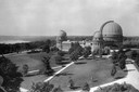
| Date: | 1935 |
|---|---|
| Description: | Elevated exterior view of Yerkes Observatory. Geneva Lake is in the background, left. Roads and sidewalks cross the sweeping, well tended lawns. The desi... |

| Date: | 1823 |
|---|---|
| Description: | In 1823 U.S. Army major Stephen H. Long led an expedition of scientific, trade, and military investigation up the Mississippi River and the Red River of th... |
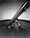
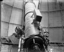
| Date: | 1930 |
|---|---|
| Description: | Telescope at Washburn Observatory with man at controls. |
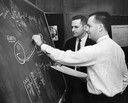
| Date: | 05 14 1963 |
|---|---|
| Description: | Lunar trajectory paths and computations on a blackboard are discussed by employees of Milwaukee's Astronautics, Inc. |
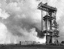
| Date: | 1961 |
|---|---|
| Description: | A Saturn C-1 booster rocket (later renamed Saturn 1) during a static firing at the Marshall Space Flight Center. This test was an early stage in the develo... |
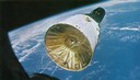
| Date: | 12 15 1965 |
|---|---|
| Description: | The Gemini 7 spacecraft as photographed by the Gemini 6 crew, 160 miles above the earth. The two-man crew of Gemini 7 included Frank Borman and James A. L... |
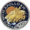
| Date: | 1972 |
|---|---|
| Description: | Mission patch design for Apollo 13. This patch was worn by Commander James A. Lovell, Jr., formerly of Milwaukee; John L. Swigert, Jr.; and Fred W Haise, ... |

| Date: | 1893 |
|---|---|
| Description: | Front and back covers of an advertising brochure for the New Empire line of mowers, reapers and grain binders manufactured by J.F. Seiberling & Company. Th... |
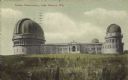
| Date: | 1905 |
|---|---|
| Description: | View across field towards the observatory. Caption reads: "Yerkes Observatory, Lake Geneva, Wis." |

| Date: | 1935 |
|---|---|
| Description: | The entrance to Yerkes Observatory. Caption reads: "Entrance, Yerkes Observatory, University of Chicago, at Williams Bay, Wis." |

| Date: | 1855 |
|---|---|
| Description: | Map reads "Our Country" which is accompanied by a sailor with a flag to the left and workers rejoicing under the Constitution and Laws to the right. Across... |
| Date: | 1910 |
|---|---|
| Description: | The telescope inside the dome at Yerkes Observatory. |
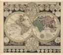
| Date: | 1745 |
|---|---|
| Description: | A two page world map featuring the Eastern and Western Hemispheres, as well as the northern and southern zodiacs. Additionally, the map is ordained with n... |
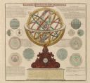
| Date: | 1745 |
|---|---|
| Description: | A two page illustration featuring a small globe in the center of numerous astrological spheres. Additionally, the representation features writing, in Lati... |

| Date: | 1836 |
|---|---|
| Description: | This map depicts Wisconsin and Michigan territories in 1836. It includes the area from Michigan to the Missouri River and Lake Winnipeg, and it shows the e... |
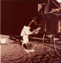
| Date: | 1970 |
|---|---|
| Description: | An Apollo 12 astronaut and lunar landing module on the moon's surface. The beryllium container in the foreground was built by the Solar Division of Interna... |

| Date: | 08 22 1961 |
|---|---|
| Description: | Portrait of Dr. Krafft A. Ehricke, program director of the astronautics division of General Dynamics Corporation. He spoke at the Wisconsin Union Theater t... |

| Date: | 1761 |
|---|---|
| Description: | This map shows the western hemisphere. Much of the north-west coast of North America is left blank, but the rest of the map lists the names of rivers, citi... |

| Date: | 1790 |
|---|---|
| Description: | An updated and corrected version of Robert de Vaugondy's 1750 map "Amérique Septentrionale: Dressée sur les Relations les Plus Modernes des Voyageurs et Na... |

| Date: | 1783 |
|---|---|
| Description: | This map is hand-colored and shows the boundaries of British, Spanish, and the newly recognized American claims, as well as the fishing rights granted to F... |
If you didn't find the material you searched for, our Library Reference Staff can help.
Call our reference desk at 608-264-6535 or email us at: