Filter: Categories of Wisconsin Historical Images
Filter: Subject of Exploration
Filter: Subject of persons
Filter: Subject of human settlements
Filter: Categories of Wisconsin Historical Images
Filter: Subject of Exploration
Filter: Subject of persons
Filter: Subject of human settlements
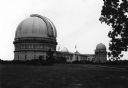
| Date: | 1935 |
|---|---|
| Description: | Elevated exterior view of Yerkes Observatory. Geneva Lake is in the background, left. Roads and sidewalks cross the sweeping, well tended lawns. The desi... |
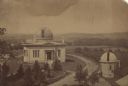
| Date: | 1880 |
|---|---|
| Description: | Elevated view of the University of Wisconsin-Madison Washburn Observatory. Hill, trees and fields are in the background. A man is standing near a small obs... |

| Date: | 1935 |
|---|---|
| Description: | The entrance to Yerkes Observatory. Caption reads: "Entrance, Yerkes Observatory, University of Chicago, at Williams Bay, Wis." |
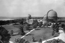
| Date: | 1950 |
|---|---|
| Description: | Bird's-eye view of Yerkes Observatory. |

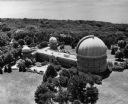
| Date: | 10 03 1976 |
|---|---|
| Description: | Exterior of Washburn Observatory, a gift to the University of Wisconsin-Madison from Cadwallader C. Washburn, on Observatory Hill overlooking Lake Mendota,... |

| Date: | 1855 |
|---|---|
| Description: | Map reads "Our Country" which is accompanied by a sailor with a flag to the left and workers rejoicing under the Constitution and Laws to the right. Across... |

| Date: | 1710 |
|---|---|
| Description: | A seminal and fairly accurate map of the Great Lakes Region up to Baffin's Bay in Northern Canada. This is possibly the first printed map to locate Detroit... |

| Date: | 1715 |
|---|---|
| Description: | One of Herman Moll's most famous maps, often referred to as The Codfish Map, it shows rivers and portages, cities, Indian villages, wind directions, routes... |

| Date: | 1780 |
|---|---|
| Description: | This map shows the northern Pacific Ocean with North America and Asia, with cities and geographical features labeled, as well Russian, French and Spanish r... |

| Date: | 1783 |
|---|---|
| Description: | This map is hand-colored and shows the boundaries of British, Spanish, and the newly recognized American claims, as well as the fishing rights granted to F... |

| Date: | 1676 |
|---|---|
| Description: | Detailed map of North and South America. Cities, towns, forests, and mountains are shown pictorially. Duval labels regions, islands, cities, lakes, and Nat... |

| Date: | 1685 |
|---|---|
| Description: | A detailed map of the western hemisphere showing cities, settlements, Native American land, rivers, lakes, mountains, the Great Lakes, and California as an... |

| Date: | 1746 |
|---|---|
| Description: | Detailed map of the western hemisphere and part of Africa and Europe. Islands, cities, settlements, rivers, lakes, countries, and regions are marked. Mount... |

| Date: | 1759 |
|---|---|
| Description: | Map of North and South America showing regions, colonies, cities and settlements, rivers, lakes, and Native American land. Near the bottom left an inset ma... |

| Date: | 1684 |
|---|---|
| Description: | Map of North America showing some colonies, cities, rivers, lakes, and Native American land. Ship routes spread across both oceans, including one decorated... |

| Date: | 1710 |
|---|---|
| Description: | Map of North America showing the European claims, Native American land and villages, rivers, lakes, cities, and notes on explorers, discoveries, and topogr... |

| Date: | 1713 |
|---|---|
| Description: | Map showing the regions explored by Robert de La Salle between 1681 and 1686, as well as the route La Salle, and later Henri Joutel, took, moving north fro... |
If you didn't find the material you searched for, our Library Reference Staff can help.
Call our reference desk at 608-264-6535 or email us at: