 Filter: Categories of Wisconsin Historical Images
Filter: Subject of Engraving
Filter: Subject of writing
Filter: Categories of Wisconsin Historical Images
Filter: Subject of Engraving
Filter: Subject of writing
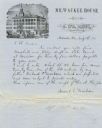
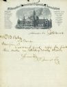
| Date: | 1857 |
|---|---|
| Description: | Letter on stationery featuring an engraving of an exterior view of the Milwaukee House showing horse-drawn vehicles and people standing on the sidewalk in ... |

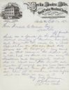
| Date: | |
|---|---|
| Description: | Letterhead stationery featuring an engraving of the Milwaukee Iron Company foundry. The letter is from an officer of the company to noted geologist Increas... |
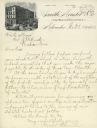
| Date: | 1883 |
|---|---|
| Description: | Engraved letterhead of the firm of Smith, Mendel & Co., a wholesale grocery merchant. William E. Smith was a prominent Milwaukee businessman, partner in th... |
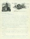
| Date: | 1900 |
|---|---|
| Description: | Letterhead stationery of Wendell Anderson, the mayor of La Crosse, with an engraving of city hall. |
| Date: | 1900 |
|---|---|
| Description: | Letterhead stationery of David S. Rose, the mayor of Milwaukee, showing an engraving of Milwaukee City Hall. |
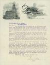
| Date: | 1883 |
|---|---|
| Description: | Letterhead stationery of the Milwaukee Industrial Exposition Association, with an engraving of the building constructed for that event. |
| Date: | 1876 |
|---|---|
| Description: | Letterhead of the Berlin Woolen Mills bearing an engraving of the factory, which is unusual because of its French Mansard roof. |

| Date: | 1776 |
|---|---|
| Description: | This was one of the first maps available for the general British populace featuring America during the Revolutionary War. It includes forts, cities, topogr... |

| Date: | 1769 |
|---|---|
| Description: | Double hemispherical map showing the continents, islands, countries, and a few major cities of the world. The routes of a few explorers are depicted and la... |

| Date: | 1780 |
|---|---|
| Description: | Map of North and South America, showing the boundaries of colonial territories, cities, settlements, rivers, lakes, and Native American land. Particular em... |

| Date: | 1747 |
|---|---|
| Description: | Map of America showing rivers, lakes, mountains, and regions, but primarily focusing on the French and Native American settlements along the Mississippi th... |

| Date: | 1758 |
|---|---|
| Description: | Map showing lakes, rivers, cities, Native American land, and the boundaries of French and English claims in America and Canada north of New York. A title c... |

| Date: | 1762 |
|---|---|
| Description: | Map including the land and islands surrounding the Gulf of Mexico. The regions and islands are labeled, as are a few rivers and cities. This map was engrav... |

| Date: | 1676 |
|---|---|
| Description: | Map of Virginia and Maryland, based on John Smith's 1612 map and Augustine Herman's 1673 seminal map. It shows borders, counties, Native American land, tri... |
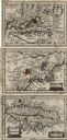
| Date: | 1675 |
|---|---|
| Description: | Three maps found within John Speed's atlas A Prospect of the Most Famous Parts of the World along with the corresponding text. The first map shows V... |
If you didn't find the material you searched for, our Library Reference Staff can help.
Call our reference desk at 608-264-6535 or email us at: