 Filter: Categories of Wisconsin Historical Images
Filter: Subject of Engraving
Filter: Subject of water
Filter: Subject of land use
Filter: Categories of Wisconsin Historical Images
Filter: Subject of Engraving
Filter: Subject of water
Filter: Subject of land use

| Date: | 1847 |
|---|---|
| Description: | Engraving of the McCormick Reaper Works as it appeared in 1847. The factory was located on the north bank of the Chicago River, east of the Michigan Avenue... |

| Date: | 1937 |
|---|---|
| Description: | Bird's-eye view of Milwaukee in 1853 details building features and city layout from southwest. Important buildings are numbered in a silhouette drawing bel... |
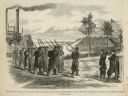
| Date: | 02 28 1863 |
|---|---|
| Description: | The First Regiment of the Louisiana Native Guards disembarking at Fort Macomb, Louisiana. The fort is adjacent to the Venetian Isles community, now legally... |

| Date: | 1930 |
|---|---|
| Description: | Color illustration of the Rush Street Bridge and Chicago River as it appeared in 1861. Includes the C.H. McCormick Reaper Works on the far side of the rive... |
| Date: | |
|---|---|
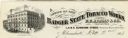
| Description: | Letterhead of the Badger State Tobacco Works of Milwaukee, Wisconsin, with a three-quarter view of the building, men working on boats moored near the water... |
| Date: | |
|---|---|
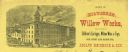
| Description: | Letterhead of the Milwaukee Willow Works, a manufacturer of children's carriages, willow ware, and toys, with a three-quarter view of the company building,... |

| Date: | |
|---|---|
| Description: | A scene including the American Fur Company buildings, an American flag, a lake and people in boats. |
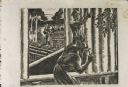
| Date: | 1937 |
|---|---|
| Description: | Linoleum cut engraved view of men building a log cabin. One man carries a log in the background near a lake or river, while another man nails a log held in... |
| Date: | 1880 |
|---|---|
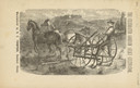
| Description: | Front page of booklet with an engraving of a man with a team of two horses in a field with the "Celebrated Gorham Sulky Cultivator." |
| Date: | 1856 |
|---|---|
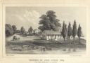
| Description: | Lithograhic view of the residence of John Kinzie on the bank of the Chicago River at the mouth of Lake Michigan. The residence consists of a house with a f... |

| Date: | 1877 |
|---|---|
| Description: | Engraving of the Peck Cabin, after the painting by Mrs. E.E. Bailey. Caption at bottom reads: "First House in Madison. 1837." |

| Date: | 1715 |
|---|---|
| Description: | A map of the countries and islands surrounding the Gulf of Mexico. The hand-colored borders separate the territories of England, France, Spain, and Holland... |

| Date: | 1782 |
|---|---|
| Description: | Map of the West Indies and south eastern North America, remarkably detailed, showing cities, mountains, rivers, lakes, mines, plantations, forts, banks, an... |

| Date: | 1758 |
|---|---|
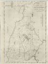
| Description: | This detailed map of north eastern America shows the boundaries, cities, mountains, rivers, lakes, Native American land and towns, and roads from east of t... |

| Date: | 1790 |
|---|---|
| Description: | This map of the north eastern states shows roads, rivers, lakes, waterfalls, mountains, cities, forts, mills, the Oneida Reservation, and "New York Donatio... |

| Date: | 1770 |
|---|---|
| Description: | The south west sheet of a four sheet map of Virginia, showing the counties, mountains, rivers, court houses, a few cities, and mills. A few Plantations ar... |

| Date: | 1776 |
|---|---|
| Description: | Map of New Jersey and New York, showing cities, forts, roads, counties, townships, land grants, rivers, lakes and several topographical features. Much of t... |

| Date: | 1775 |
|---|---|
| Description: | Map of Boston and surrounding regions, from Massachusetts Bay to the Connecticut River, and including part of southern New Hampshire. It shows the colonies... |
| Date: | 1791 |
|---|---|
| Description: | Detailed map of New Hampshire. It shows counties, cities, mountains, highlands, lakes, and rivers. The acres given to Dartmouth College are labeled far in ... |

| Date: | 03 1777 |
|---|---|
| Description: | Map showing the British and Hessian attack on Fort Washington in November of 1776. The movements and fortifications of the British and Hessian troops appea... |
If you didn't find the material you searched for, our Library Reference Staff can help.
Call our reference desk at 608-264-6535 or email us at: