 Filter: Categories of Wisconsin Historical Images
Filter: Subject of Engraving
Filter: Subject of science
Filter: Categories of Wisconsin Historical Images
Filter: Subject of Engraving
Filter: Subject of science
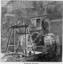
| Date: | 05 1866 |
|---|---|
| Description: | Engraved view of two men in a train locomotive observing the weighing of pig lead. Several bars of lead are stacked near the scale. |

| Date: | 03 02 1934 |
|---|---|
| Description: | A man exposing a negative onto a zinc plate, in preparation for making a zinc etching at Wisconsin Engraving Co., 109 S. Carroll Street. |

| Date: | 03 02 1934 |
|---|---|
| Description: | A man in the camera room at the Wisconsin Engraving Company plant, 109 S. Carroll Street, is coating the wet plate negative with rubber and collodion to ma... |
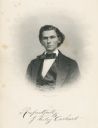
| Date: | 1880 |
|---|---|
| Description: | Engraved portrait of J. Wesley Carhart of Racine, Methodist minister, physician, and inventor of a steam-powered automobile in 1871. Although impractical, ... |

| Date: | |
|---|---|
| Description: | Engraved portrait of Charles W. Short (1794-1863), Kentucky botanist. Worked at Transylvania University in Lexington, Kentucky, 1825-38. The plant genus ... |
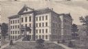
| Date: | 1876 |
|---|---|
| Description: | Engraving of the first Science Hall at University of Wisconsin-Madison. |

| Date: | 1923 |
|---|---|
| Description: | Drawing of a tree with a banner over it reading Eugenics. The roots of the tree are labeled with sciences and fields connected to eugenics. Text on ... |

| Date: | 04 29 1934 |
|---|---|
| Description: | An illustrated, sensational article about giant robots replacing soldiers in fighting wars. |

| Date: | 1712 |
|---|---|
| Description: | Engraved double-hemispherical world map by Moll, included in his atlas The world described, or, A new and correct sett of maps: shewing the kingdoms and st... |
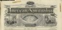
| Date: | 1872 |
|---|---|
| Description: | Engraved masthead for The American Spiritualist depicting a seance over the word "phenomenal," a globe over the word "scientific," and a man at a de... |

| Date: | 1760 |
|---|---|
| Description: | A map of the world in two hemispheres, with the borders of the continents hand-colored. This map contains 14 spherical diagrams of the cosmos, portraying t... |

| Date: | 1761 |
|---|---|
| Description: | This map shows the western hemisphere. Much of the north-west coast of North America is left blank, but the rest of the map lists the names of rivers, citi... |

| Date: | 1786 |
|---|---|
| Description: | This map is an updated version of d'Anville's 1761 map of the western hemisphere. He included more details to the north west coast of North America, partic... |

| Date: | 1710 |
|---|---|
| Description: | A seminal and fairly accurate map of the Great Lakes Region up to Baffin's Bay in Northern Canada. This is possibly the first printed map to locate Detroit... |

| Date: | 1715 |
|---|---|
| Description: | One of Herman Moll's most famous maps, often referred to as The Codfish Map, it shows rivers and portages, cities, Indian villages, wind directions, routes... |

| Date: | 1720 |
|---|---|
| Description: | This map of North America shows cities, rivers, lakes, and a few topographical features, complete with numerous descriptive blocks of text about expedition... |

| Date: | 1780 |
|---|---|
| Description: | This map shows the northern Pacific Ocean with North America and Asia, with cities and geographical features labeled, as well Russian, French and Spanish r... |

| Date: | 1755 |
|---|---|
| Description: | This map shows forts, missions, villages and cities, rivers and portages, and boundaries of the Spanish, English, and French territories, marking the large... |

| Date: | 1786 |
|---|---|
| Description: | One half of a four sheet nautical chart, showing the coastlines of the north-west hemisphere. The interior lands are left bare, even of basic features such... |

| Date: | 1775 |
|---|---|
| Description: | This map shows the northern Pacific Ocean along with north eastern Asia and western North America. The interior of Asia contains detailed engravings of pla... |
If you didn't find the material you searched for, our Library Reference Staff can help.
Call our reference desk at 608-264-6535 or email us at: