 Filter: Categories of Wisconsin Historical Images
Filter: Subject of Engraving
Filter: Subject of military art and science
Filter: Subject of human settlements
Filter: Categories of Wisconsin Historical Images
Filter: Subject of Engraving
Filter: Subject of military art and science
Filter: Subject of human settlements

| Date: | 1655 |
|---|---|
| Description: | Map from Drake Expedition in Florida, ca. 1585. |

| Date: | 1655 |
|---|---|
| Description: | Scene from Jamestown Settlement, 1622, purporting to show the massacre of 347 settlers by Openchancanough and his alliance of tribes in the Jamestown area. |

| Date: | 1868 |
|---|---|
| Description: | Elevated view of the Grant County Soldier's Monument. A group of people are standing around the monument. A large building is in the background. Caption at... |

| Date: | 1862 |
|---|---|
| Description: | Birds-eye view of a Wisconsin Civil War regiment on parade in Fond du Lac, as drawn by Louis Kurz from the Marr Street Methodist Church. The regiment canno... |

| Date: | 1870 |
|---|---|
| Description: | Magazine illustration of the home, titled: "Soldiers' National Asylum at Milwaukee, Wisconsin". The building is in the background, and in the foreground ar... |
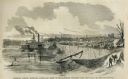
| Date: | 05 31 1862 |
|---|---|
| Description: | Engraved view of the Commisary [sic] depot of Major-General Halleck's army at Hamburg Landing. |

| Date: | 1819 |
|---|---|
| Description: | A commemorative handkerchief created by a wood engraving on white cotton fabric. The scene is the Manchester Reform Meeting, in England. A crowd of demonst... |

| Date: | 1776 |
|---|---|
| Description: | This was one of the first maps available for the general British populace featuring America during the Revolutionary War. It includes forts, cities, topogr... |

| Date: | 1783 |
|---|---|
| Description: | This map is hand-colored and shows the boundaries of British, Spanish, and the newly recognized American claims, as well as the fishing rights granted to F... |

| Date: | 1758 |
|---|---|
| Description: | This detailed map of north eastern America shows the boundaries, cities, mountains, rivers, lakes, Native American land and towns, and roads from east of t... |

| Date: | 1777 |
|---|---|
| Description: | Map showing the Hudson River in three sections, from New York City up through Lake Champlain, including cities, forts, roads, topographical features, and n... |

| Date: | 1719 |
|---|---|
| Description: | Map of the Great Lakes and the St. Lawrence river showing French and English cities and villages, trading posts, Indian villages and tribes, portages, for... |

| Date: | 1733 |
|---|---|
| Description: | This map of North America shows settlements, rivers, lakes, Native American land, trade winds, and numerous topographical features such as forests and moun... |

| Date: | 1755 |
|---|---|
| Description: | Large format map of America and Canada east of the Mississippi River. D'Anville marks the locations of rivers, lakes, settlements, cities, Native American ... |

| Date: | 1758 |
|---|---|
| Description: | Map showing lakes, rivers, cities, Native American land, and the boundaries of French and English claims in America and Canada north of New York. A title c... |

| Date: | 1770 |
|---|---|
| Description: | Map of North America from the Great Lakes to the northern portion of South America. It shows cities, Native American land, mountains, swamps, lakes, rivers... |

| Date: | 1776 |
|---|---|
| Description: | Map of the American colonies and land east of the Mississippi River. Prominent cities, forts, Native American land, mountains, rivers and lakes are all sho... |

| Date: | 1780 |
|---|---|
| Description: | Map of North America east of Mexico showing colonial boundaries, forts, cities, Native American land, mountains, waterfalls, lakes, and rivers. Short notes... |

| Date: | 02 1783 |
|---|---|
| Description: | Map of the United States and one of the first to show the new boundaries created by the Preliminary Treaty signed on January 20, 1783. The former colonies ... |

| Date: | 1782 |
|---|---|
| Description: | Map of America east of the Mississippi River. It shows regions, state boundaries extending to the Mississippi River, cities, forts, Native American lands, ... |
If you didn't find the material you searched for, our Library Reference Staff can help.
Call our reference desk at 608-264-6535 or email us at: