 Filter: Categories of Wisconsin Historical Images
Filter: Subject of Engraving
Filter: Subject of men
Filter: Subject of science
Filter: Categories of Wisconsin Historical Images
Filter: Subject of Engraving
Filter: Subject of men
Filter: Subject of science
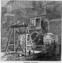
| Date: | 05 1866 |
|---|---|
| Description: | Engraved view of two men in a train locomotive observing the weighing of pig lead. Several bars of lead are stacked near the scale. |

| Date: | 03 02 1934 |
|---|---|
| Description: | A man exposing a negative onto a zinc plate, in preparation for making a zinc etching at Wisconsin Engraving Co., 109 S. Carroll Street. |

| Date: | 03 02 1934 |
|---|---|
| Description: | A man in the camera room at the Wisconsin Engraving Company plant, 109 S. Carroll Street, is coating the wet plate negative with rubber and collodion to ma... |

| Date: | 1880 |
|---|---|
| Description: | Engraved portrait of J. Wesley Carhart of Racine, Methodist minister, physician, and inventor of a steam-powered automobile in 1871. Although impractical, ... |

| Date: | |
|---|---|
| Description: | Engraved portrait of Charles W. Short (1794-1863), Kentucky botanist. Worked at Transylvania University in Lexington, Kentucky, 1825-38. The plant genus ... |

| Date: | 1712 |
|---|---|
| Description: | Engraved double-hemispherical world map by Moll, included in his atlas The world described, or, A new and correct sett of maps: shewing the kingdoms and st... |
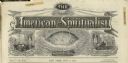
| Date: | 1872 |
|---|---|
| Description: | Engraved masthead for The American Spiritualist depicting a seance over the word "phenomenal," a globe over the word "scientific," and a man at a de... |

| Date: | 1710 |
|---|---|
| Description: | A seminal and fairly accurate map of the Great Lakes Region up to Baffin's Bay in Northern Canada. This is possibly the first printed map to locate Detroit... |

| Date: | 1715 |
|---|---|
| Description: | One of Herman Moll's most famous maps, often referred to as The Codfish Map, it shows rivers and portages, cities, Indian villages, wind directions, routes... |

| Date: | 1780 |
|---|---|
| Description: | This map shows the northern Pacific Ocean with North America and Asia, with cities and geographical features labeled, as well Russian, French and Spanish r... |

| Date: | 1783 |
|---|---|
| Description: | This map is hand-colored and shows the boundaries of British, Spanish, and the newly recognized American claims, as well as the fishing rights granted to F... |

| Date: | 1746 |
|---|---|
| Description: | This world map from the German mathematician, historian, and geographer Johann Matthias Hase shows the major cities, islands, and the major political divis... |

| Date: | 1676 |
|---|---|
| Description: | Detailed map of North and South America. Cities, towns, forests, and mountains are shown pictorially. Duval labels regions, islands, cities, lakes, and Nat... |

| Date: | 1685 |
|---|---|
| Description: | A detailed map of the western hemisphere showing cities, settlements, Native American land, rivers, lakes, mountains, the Great Lakes, and California as an... |

| Date: | 1746 |
|---|---|
| Description: | Detailed map of the western hemisphere and part of Africa and Europe. Islands, cities, settlements, rivers, lakes, countries, and regions are marked. Mount... |

| Date: | 1759 |
|---|---|
| Description: | Map of North and South America showing regions, colonies, cities and settlements, rivers, lakes, and Native American land. Near the bottom left an inset ma... |

| Date: | 1684 |
|---|---|
| Description: | Map of North America showing some colonies, cities, rivers, lakes, and Native American land. Ship routes spread across both oceans, including one decorated... |

| Date: | 1710 |
|---|---|
| Description: | Map of North America showing the European claims, Native American land and villages, rivers, lakes, cities, and notes on explorers, discoveries, and topogr... |

| Date: | 1713 |
|---|---|
| Description: | Map showing the regions explored by Robert de La Salle between 1681 and 1686, as well as the route La Salle, and later Henri Joutel, took, moving north fro... |

| Date: | 1760 |
|---|---|
| Description: | Map of North America based upon the cartographic work of de L'Isle. It shows cities, regions, lakes, rivers, Native American land, mountains, islands, and ... |
If you didn't find the material you searched for, our Library Reference Staff can help.
Call our reference desk at 608-264-6535 or email us at: