 Filter: Categories of Wisconsin Historical Images
Filter: Subject of Engraving
Filter: Subject of men
Filter: Subject of clothing
Filter: Categories of Wisconsin Historical Images
Filter: Subject of Engraving
Filter: Subject of men
Filter: Subject of clothing
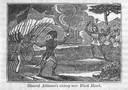
| Date: | 1845 |
|---|---|
| Description: | Illustration of Chippewa and Sioux Indians battling each other at the Brule River. Wood engraving from Armstrong, "Early Life Among The Indians." |
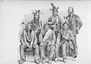
| Date: | 06 24 1852 |
|---|---|
| Description: | Illustration of the Washington, D.C. Delegation of Indians. Five Indians pose with a man in a beard and suit. From Benjamin Armstrong, "Early Life Among Th... |
| Date: | |
|---|---|
| Description: | Photograph of an engraving from an unknown source depicting a group of Native American warriors herding white captives along a trail. A building burns in ... |
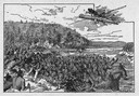
| Date: | 1845 |
|---|---|
| Description: | Engraving depicting the defeat of Black Hawk by General Henry Atkinson at the Battle of Bad Axe on August 2, 1832. The engraving depicts Federal Regulars a... |

| Date: | 1655 |
|---|---|
| Description: | Frontispiece to Newe Welt vnd americanische Historien (1655). |
| Date: | 1655 |
|---|---|
| Description: | Engraving made after a painting by Jacques Le Moyne de Morgues (died 1588) while on the Laudonnière Expedition in Florida, ca. 1564. |
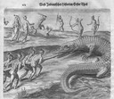
| Date: | 1655 |
|---|---|
| Description: | Engraving made after a painting by Jacques Le Moyne de Morgues (died 1588) while on the Laudonnière Expedition in Florida, ca. 1564. |
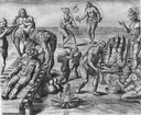
| Date: | 1655 |
|---|---|
| Description: | Depicts Indians encountered on the Barlowe and Amadas Expedition in Virgina, ca. 1584. |

| Date: | 1784 |
|---|---|
| Description: | Plate 45. Scene from Cook's Third Expedition, 1776-1779, while in Alaska. |
| Date: | 1884 |
|---|---|
| Description: | A engraving of the artist's conception of Pawnees torturing a female captive in the Morning Star Sacrifice ceremony. |
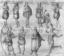
| Date: | |
|---|---|
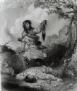
| Description: | "Death Whoop" an engraving after a drawing by Seth Eastman from the American Aboriginal Portfolio. |
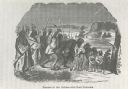
| Date: | 1884 |
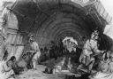
|---|---|
| Description: | Group of Ho-Chunk (Winnebago) Indians in a long house (ciproke). Some of the men are displaying animal pelts. There is a bucket and a small barrel at the e... |
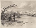
| Date: | 1884 |
|---|---|
| Description: | Small group of Native Americans spearing fish through ice on a river. Mountains can be seen in the background. |
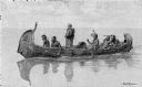
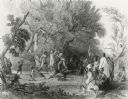
| Date: | 1892 |
|---|---|
| Description: | Photographic print of an engraved image showing a robed missionary standing in a birch bark canoe paddled by four Native Americans and another man who appe... |

| Date: | 1627 |
|---|---|
| Description: | Map of North and South America showing settlements, rivers, lakes, mountains, islands and regions of the western hemisphere. It includes an inset map of Gr... |

| Date: | 1630 |
|---|---|
| Description: | One of the few maps by Dutch cartographer Willem Blaeu depicting the Americas, this map shows regions, settlements, islands, mountains, forests, rivers, an... |

| Date: | 1759 |
|---|---|
| Description: | Map of North and South America showing regions, colonies, cities and settlements, rivers, lakes, and Native American land. Near the bottom left an inset ma... |

| Date: | 1636 |
|---|---|
| Description: | Map of North America, divided into regions, and showing some rivers, lakes, settlements, cities, mountains, and Native American land. Of the Great Lakes on... |

| Date: | 1770 |
|---|---|
| Description: | Map of North America from the Great Lakes to the northern portion of South America. It shows cities, Native American land, mountains, swamps, lakes, rivers... |

| Date: | 1720 |
|---|---|
| Description: | Detailed, ornate, and comprehensive map of America from the east coast to present day Texas. Numerous features appear throughout the map, including Native ... |
If you didn't find the material you searched for, our Library Reference Staff can help.
Call our reference desk at 608-264-6535 or email us at: