 Filter: Categories of Wisconsin Historical Images
Filter: Subject of Engraving
Filter: Subject of lakes
Filter: Subject of dwellings
Filter: Categories of Wisconsin Historical Images
Filter: Subject of Engraving
Filter: Subject of lakes
Filter: Subject of dwellings

| Date: | 1937 |
|---|---|
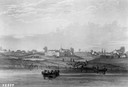
| Description: | Bird's-eye view of Milwaukee in 1853 details building features and city layout from southwest. Important buildings are numbered in a silhouette drawing bel... |
| Date: | 1820 |
|---|---|
| Description: | Engraving of Fort Dearborn (center) and Kinzie Mansion (right) after Seth Eastman's original drawing in 1820 for the U. S. Army. Several people are visible... |
| Date: | |
|---|---|
| Description: | Engraving of a wooden shack on a Lake Michigan beach surrounded by rowboats, a campfire, and a wooded bluff. Two men stand on the beach near the water. |

| Date: | |
|---|---|
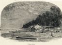
| Description: | A scene including the American Fur Company buildings, an American flag, a lake and people in boats. |

| Date: | 1937 |
|---|---|
| Description: | Linoleum cut engraved view of men building a log cabin. One man carries a log in the background near a lake or river, while another man nails a log held in... |
| Date: | 1856 |
|---|---|
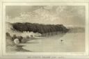
| Description: | Lithographic view of Four Legs Village at the outlet of Lake Winnebago. There are is a person in a canoe on the river and a large tree in the foreground. S... |
| Date: | 1856 |
|---|---|
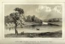
| Description: | Lithographic view of a man in a canoe on Big-Foot's Lake (modern day Lake Geneva) with a small settlement on a bluff overlooking the lake. A group of birds... |

| Date: | 1877 |
|---|---|
| Description: | Engraving of the Peck Cabin, after the painting by Mrs. E.E. Bailey. Caption at bottom reads: "First House in Madison. 1837." |

| Date: | 1720 |
|---|---|
| Description: | This map of North America shows cities, rivers, lakes, and a few topographical features, complete with numerous descriptive blocks of text about expedition... |

| Date: | 1780 |
|---|---|
| Description: | This map shows the townships, parishes, cities, towns, plantations, lakes, rivers, swamps, and roads near the coast of South Carolina and Georgia. Emphasis... |

| Date: | 1783 |
|---|---|
| Description: | Map of eastern Canada and part of America, with an inset map of the Great Lakes region in the lower left corner. It shows boundaries, cities, settlements, ... |

| Date: | 1718 |
|---|---|
| Description: | Map of the Southern portion of North America from New Mexico to Florida and south from Lake Erie. It shows borders, cities, settlements, Native American la... |

| Date: | 1776 |
|---|---|
| Description: | Map of Virginia and parts of Maryland and Delaware (written "De La War"). It shows borders, counties, cities, towns, plantations (marked by landowners name... |
If you didn't find the material you searched for, our Library Reference Staff can help.
Call our reference desk at 608-264-6535 or email us at: