 Filter: Categories of Wisconsin Historical Images
Filter: Subject of Engraving
Filter: Subject of indians of north america
Filter: Subject of agriculture
Filter: Categories of Wisconsin Historical Images
Filter: Subject of Engraving
Filter: Subject of indians of north america
Filter: Subject of agriculture
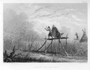
| Date: | 1884 |
|---|---|
| Description: | Indian women standing on platforms make noise to scare birds from the cornfield. |
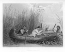
| Date: | 1884 |
|---|---|
| Description: | Three women in a canoe harvest wild rice. |

| Date: | 1655 |
|---|---|
| Description: | Frontispiece to Newe Welt vnd americanische Historien (1655). |

| Date: | 1685 |
|---|---|
| Description: | A detailed map of the western hemisphere showing cities, settlements, Native American land, rivers, lakes, mountains, the Great Lakes, and California as an... |

| Date: | 1719 |
|---|---|
| Description: | Map of Maryland and surrounding states. It shows the boundaries, counties, cities, towns, rivers, and bays. Mountains, forests, and swamps appear pictoria... |

| Date: | 1671 |
|---|---|
| Description: | Map of Virginia depicting the discoveries detailed by John Smith in his exploration of the region. It shows Jamestown, Native American tribes and villages,... |

| Date: | 1676 |
|---|---|
| Description: | Map of Virginia and Maryland, based on John Smith's 1612 map and Augustine Herman's 1673 seminal map. It shows borders, counties, Native American land, tri... |

| Date: | 1755 |
|---|---|
| Description: | Map of Virginia and parts of Maryland, North Carolina, and New Jersey. It shows borders, boundary lines, some Native American land, counties, cities, towns... |

| Date: | 1762 |
|---|---|
| Description: | Map of Virginia and parts of Maryland. It shows borders, boundary lines, Native American tribes and land, towns, forts, roads, mountains, waterfalls, bays,... |

| Date: | 1760 |
|---|---|
| Description: | Map showing the towns, mountains, valleys, corn fields, and rivers of a portion of the Cherokee Nation. A few annotations on the map explain the land and r... |
If you didn't find the material you searched for, our Library Reference Staff can help.
Call our reference desk at 608-264-6535 or email us at: