Filter: Categories of Wisconsin Historical Images
Filter: Subject of Clothing and dress
Filter: Subject of land
Filter: Subject of clothing
Filter: Categories of Wisconsin Historical Images
Filter: Subject of Clothing and dress
Filter: Subject of land
Filter: Subject of clothing

| Date: | 1835 |
|---|---|
| Description: | Little Lake Butte Des Morts just north of Lake Winnebago where Governor Lewis Cass of Michigan, and Thomas McKenney, head of the Bureau of Indian Affairs (... |
| Date: | |
|---|---|
| Description: | Painting by Cal Peters depicting the battle of Bad Axe, also known as the Bad Axe massacre, at the Mississippi River on August 2, 1832. |
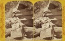
| Date: | 1873 |
|---|---|
| Description: | Native American woman, a member of the Ute Indian Tribe, seated on a rock outcropping in traditional costume. |
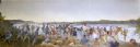
| Date: | |
|---|---|
| Description: | Panoramic view of a large group of Native Americans posed in front of Stand Rock between two tipis. |
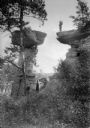
| Date: | 1930 |
|---|---|
| Description: | A man in Native American clothing is standing on the ledge near Stand Rock. Two women are watching from the ground below. |
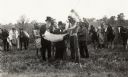
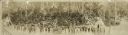
| Date: | 1949 |
|---|---|
| Description: | Historical re-enactment outdoors, in inappropriate attire, probably meant to represent a treaty signing, at the Grignon House. |
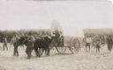
| Date: | |
|---|---|
| Description: | Photographic postcard of a scene from the Apostle Island Indian Pageant. Two children are sitting aboard a covered wagon pulled by a pair of steers while t... |

| Date: | 1937 |
|---|---|
| Description: | Label submitted to the state of Wisconsin for trademark registration. "Pioneer Beer, G. Weber Brewing Co." Under this in the center is a leaf with the lett... |

| Date: | 1627 |
|---|---|
| Description: | Map of North and South America showing settlements, rivers, lakes, mountains, islands and regions of the western hemisphere. It includes an inset map of Gr... |

| Date: | 1630 |
|---|---|
| Description: | One of the few maps by Dutch cartographer Willem Blaeu depicting the Americas, this map shows regions, settlements, islands, mountains, forests, rivers, an... |

| Date: | 1770 |
|---|---|
| Description: | Map of North America from the Great Lakes to the northern portion of South America. It shows cities, Native American land, mountains, swamps, lakes, rivers... |

| Date: | 1720 |
|---|---|
| Description: | Detailed, ornate, and comprehensive map of America from the east coast to present day Texas. Numerous features appear throughout the map, including Native ... |

| Date: | 1667 |
|---|---|
| Description: | Map of Virginia depicting the discoveries detailed by John Smith in his exploration of the region. It shows Jamestown, Native American tribes and villages,... |

| Date: | 1671 |
|---|---|
| Description: | Map of Virginia depicting the discoveries detailed by John Smith in his exploration of the region. It shows Jamestown, Native American tribes and villages,... |
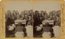
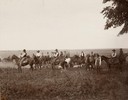
| Date: | 1870 |
|---|---|
| Description: | Ojibwa Indians receiving annuity payment. Seated on the right is John W. Bell. Others are, left to right, Asaph Whittlesey, Agent Henry C. Gilbert, and Wil... |

| Date: | 1930 |
|---|---|
| Description: | Text reads: "Souvenir Folder. Dells of the Wisconsin." The mailing side/front of a souvenir view folder containing eleven accordion folded, double-sided co... |
If you didn't find the material you searched for, our Library Reference Staff can help.
Call our reference desk at 608-264-6535 or email us at: