Filter: Categories of Wisconsin Historical Images
Filter: Subject of Clothing and dress
Filter: Subject of human settlements
Filter: Subject of forests and forestry
Filter: Categories of Wisconsin Historical Images
Filter: Subject of Clothing and dress
Filter: Subject of human settlements
Filter: Subject of forests and forestry
| Date: | |
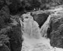
|---|---|
| Description: | Elevated view of the falls. There are three men at the top of the falls. |
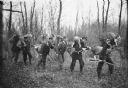
| Date: | 1910 |
|---|---|
| Description: | Hunters dragging deer from woods. In the center is Frank Langeois, son of Joseph Jr. |

| Date: | |
|---|---|
| Description: | View of Main Avenue, a winding dirt road passing through a pine forest, at Wellesley College. A woman walks along a wooden walkway adjacent to the road. |

| Date: | |
|---|---|
| Description: | Elevated view of Shepperd's Dell Bridge on the Columbia River Highway, a historic scenic road. People stand near the railing to look out over the bridge. R... |
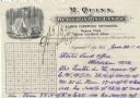
| Date: | |
|---|---|
| Description: | Letterhead of M. Quinn, "Dealer in Pine Lands," with two men in front of a tent at a campsite, one of whom is cooking over a campfire and the other is sitt... |
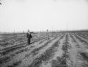
| Date: | 1895 |
|---|---|
| Description: | Two men stand in a strawberry field bordered by burnt-over forest. The photographer's shadow can be seen at the bottom of the image. |
| Date: | |
|---|---|
| Description: | The log who was made King of Logs is here entombed eight round, ten long For his design, the strengthened forest capriciously outgrew them all... |

| Date: | 03 29 1951 |
|---|---|
| Description: | Indoor group portrait of men posed with the Wisconsin Official Marker. From left to right on either side of the marker are: Clifford Lord, Secretary of Sit... |

| Date: | 1630 |
|---|---|
| Description: | One of the few maps by Dutch cartographer Willem Blaeu depicting the Americas, this map shows regions, settlements, islands, mountains, forests, rivers, an... |

| Date: | 1740 |
|---|---|
| Description: | Map including the regions and cities of the northern half of North America. Native American land, rivers, lakes, mountains are labeled. Mountains, marshes,... |

| Date: | 1784 |
|---|---|
| Description: | Detailed and ornate map of the newly formed United States. The borders of the southern states extend to the Mississippi River, though the states are only c... |

| Date: | 1720 |
|---|---|
| Description: | Detailed, ornate, and comprehensive map of America from the east coast to present day Texas. Numerous features appear throughout the map, including Native ... |

| Date: | 1673 |
|---|---|
| Description: | Decorative map of the southeastern region of North America, from the York River in Virginia to northern Florida. The coat of arms of France and England mar... |

| Date: | 1667 |
|---|---|
| Description: | Map of Virginia depicting the discoveries detailed by John Smith in his exploration of the region. It shows Jamestown, Native American tribes and villages,... |

| Date: | 1671 |
|---|---|
| Description: | Map of Virginia depicting the discoveries detailed by John Smith in his exploration of the region. It shows Jamestown, Native American tribes and villages,... |
| Date: | 1968 |
|---|---|
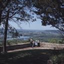
| Description: | Slightly elevated view of a family standing in front of a stone wall at Point Lookout in Wyalusing State Park. The man is pointing towards the Wisconsin Ri... |
| Date: | 1949 |
|---|---|
| Description: | A man wading and fishing in the Brule River. He is wearing waders, a plaid shirt, hat and creel, and has netted a fish. In the background is a forest and p... |
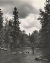
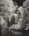
| Date: | 1950 |
|---|---|
| Description: | View across water towards a man fly fishing while standing in the river. He is wearing waders and a hat, and a creel and a net are hanging at his sides. He... |
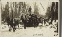
| Date: | 06 06 1911 |
|---|---|
| Description: | Text on front reads: "Rib Lake, Wis.", "Loading." and "Brown Photo." A lumberjack is standing on a load of logs pulled by a team of horses. Three more men ... |
If you didn't find the material you searched for, our Library Reference Staff can help.
Call our reference desk at 608-264-6535 or email us at: