 Filter: Categories of Wisconsin Historical Images
Filter: Subject of Cities and towns
Filter: Subject of human settlements
Filter: Subject of military camps
Filter: Categories of Wisconsin Historical Images
Filter: Subject of Cities and towns
Filter: Subject of human settlements
Filter: Subject of military camps

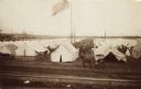
| Date: | 1862 |
|---|---|
| Description: | Camp Randall looking southwest. In April 1861, Governor Alexander Randall asked that the State Agricultural Society fairgrounds be converted into a militar... |
| Date: | 11 08 1906 |
|---|---|
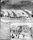
| Description: | Two Civil War watercolor drawings by John Gaddis, Company E, 12th Wisconsin Volunteer Infantry, showing the regiment in bivouac, and later their headquarte... |
| Date: | 05 1862 |
|---|---|
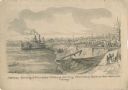
| Description: | "Hamburg Landing, 4 miles below Pittsburg Landing, Commisary [sic] Depot of Gen. Hallek's Army." An encampment with soldiers along the river with a ... |
| Date: | 1862 |
|---|---|
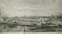
| Description: | Photograph of a watercolor of a view of Camp Randall, from the northeast. Scene set on rolling hills, shows tents, buildings, horses and military members i... |
| Date: | 05 20 1864 |
|---|---|
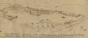
| Description: | A sketch of Camp Randall made from the top of University Building, May 20, 1864, by W.F. Brown of the 40th Wisconsin Volunteer Infantry Company B. A small... |
| Date: | 1884 |
|---|---|
| Description: | Elevated view of the Eighteenth Annual National Encampment of Grand Army of the Republic in Minneapolis, Minnesota in July 1884. |
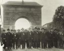
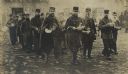
| Date: | 09 07 1917 |
|---|---|
| Description: | Reunion of the Grand Army of the Republic at Camp Randall, members of the 15th Wisconsin Volunteer Infantry (the mostly Scandinavian unit commanded by Colo... |
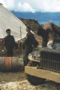
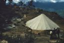
| Date: | 1961 |
|---|---|
| Description: | Keukacham Meo settlement, Laos with American special forces and Lao infantrymen. Two soldiers talk near a tent and another works atop a mud-spattered jeep. |
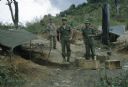
| Date: | 1961 |
|---|---|
| Description: | Three Lao infantrymen stand outside near of tents in the Keukacham village. |
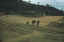
| Date: | 1961 |
|---|---|
| Description: | A woman leads a mule laden with bundles across the airstrip at the village of Keukacham, Laos. A young mule follows. In the background at the base of a hil... |
| Date: | 1961 |
|---|---|
| Description: | Elevated view of Keukacham village, Laos. Three soldiers stand talking in the foreground by a large, open, white tent. In the background is a rubble pile, ... |

| Date: | 1912 |
|---|---|
| Description: | This map from the U.S. General Land Office shows railroads, counties, cities and villages, rivers, lakes, U.S. Land Offices, Indian reservations, military ... |
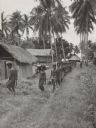
| Date: | 1943 |
|---|---|
| Description: | View down line of indigenous men, from a village near the airstrip, helping soldiers carry equipment to a camp area along a trail. Two soldiers stand off t... |
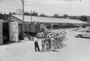
| Date: | 07 13 1945 |
|---|---|
| Description: | Elevated view of a work shift of German prisoners at a prisoner of war camp marching to a truck to be conveyed to work at a local cannery. |

| Date: | 10 1776 |
|---|---|
| Description: | Broadside map showing the British invasion of New York city in August and September of 1776. The map shows important cities, forts, roads, hills, mountains... |

| Date: | 02 1777 |
|---|---|
| Description: | Map depicting the campaigns of October and November 1776, in Manhattan, Westchester, and part of New Jersey, published only a few months after the conclusi... |

| Date: | 03 1777 |
|---|---|
| Description: | Map showing the British and Hessian attack on Fort Washington in November of 1776. The movements and fortifications of the British and Hessian troops appea... |

| Date: | 04 1777 |
|---|---|
| Description: | Map showing the area from Newtown, Pennsylvania to Kingston, New Jersey, with routes and battles of British (red) and American forces (blue). The map inclu... |

| Date: | 1766 |
|---|---|
| Description: | Map of the region south of Lake Erie to the Ohio River. It shows forts, towns, Native American towns, mines, roads, mountains, swamps, lakes, and rivers. T... |
| Date: | |
|---|---|
| Description: | French prisoners in the German PoW camp in Zossen, Prussia, with steaming bowls of soup. |
If you didn't find the material you searched for, our Library Reference Staff can help.
Call our reference desk at 608-264-6535 or email us at: