 Filter: Categories of Wisconsin Historical Images
Filter: Subject of Battles
Filter: Subject of military camps
Filter: Categories of Wisconsin Historical Images
Filter: Subject of Battles
Filter: Subject of military camps
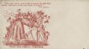
| Date: | 1860 |
|---|---|
| Description: | An old woman, stooped over and holding a cane, has Union soldiers ("NORTH" on the left) and Confederate soldiers ("SOUTH" on the right) climbing ladders to... |

| Date: | 1861 |
|---|---|
| Description: | This map shows Manassas during the First Battle of Bull Run, in which the 2nd Wisconsin Infantry fought, and the Leesburg area, the site of the Battle of B... |

| Date: | 10 1776 |
|---|---|
| Description: | Broadside map showing the British invasion of New York city in August and September of 1776. The map shows important cities, forts, roads, hills, mountains... |

| Date: | 03 1777 |
|---|---|
| Description: | Map showing the British and Hessian attack on Fort Washington in November of 1776. The movements and fortifications of the British and Hessian troops appea... |

| Date: | 04 1777 |
|---|---|
| Description: | Map showing the area from Newtown, Pennsylvania to Kingston, New Jersey, with routes and battles of British (red) and American forces (blue). The map inclu... |

| Date: | 1766 |
|---|---|
| Description: | Map of the region south of Lake Erie to the Ohio River. It shows forts, towns, Native American towns, mines, roads, mountains, swamps, lakes, and rivers. T... |
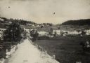
| Date: | |
|---|---|
| Description: | View of town of Lavarone in the southwest battlefront. |

| Date: | |
|---|---|
| Description: | Austrian column at rest in a Galician village. |
If you didn't find the material you searched for, our Library Reference Staff can help.
Call our reference desk at 608-264-6535 or email us at: