 Filter: Categories of Wisconsin Historical Images
Filter: Subject of Battlefields
Filter: Categories of Wisconsin Historical Images
Filter: Subject of Battlefields

| Date: | 1866 |
|---|---|
| Description: | This detailed map shows the positions of the armies of the Ohio and Tennessee, Confederate lines, headquarters, "regimental camps at the date of the battle... |

| Date: | 1867 |
|---|---|
| Description: | This map of the battlefield on the North Anna River at Hanover Junction illustrates the Union positions in blue and Confederate positions in red. Roads, ra... |
| Date: | |
|---|---|
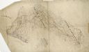
| Description: | Pen and ink tracing by Lt. Napoleon Boardman of the 2nd Wisconsin Cavalry, is colored to show positions of forces and depicts the positions of Union and Co... |

| Date: | |
|---|---|
| Description: | Pen and ink tracing showing the positions of Union and Confederate soldiers, troop camps, location of graves, roads, drainage, vegetation, houses, and fenc... |

| Date: | 1865 |
|---|---|
| Description: | The map of the battlefield shows entrenchments, villages, roads, the "South Side Rail Road" drainage, vegetation, relief by hachures, houses, and names of ... |
| Date: | 1864 |
|---|---|
| Description: | This pen and ink tracing illustrates the route traveled by Sherman's troops through Georgia, South Carolina, and North Carolina in the winter and spring of... |

| Date: | 1862 |
|---|---|
| Description: | This map consists of four separate panels. The first illustrates the battlefield at Cedar Mountain on Aug. 9, 1862, where the 3rd Wisconsin Infantry fought... |

| Date: | 1865 |
|---|---|
| Description: | This map of the Bentonville, N.C., battlefield illustrates the positions of the Union and the Confederate troops, roads, rivers, vegetation, and the names ... |

| Date: | |
|---|---|
| Description: | This detailed map shows fortifications, headquarters, location and dates of battles, street outline of Atlanta, roads, railroads, vegetation, drainage, rel... |
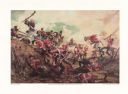
| Date: | 1985 |
|---|---|
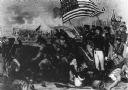
| Description: | Painting depicting the Battle of New Orleans, fought on 8 January 1815. In the upper corner of the painting Major General Andrew Jackson is shown at the to... |
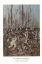
| Date: | 1982 |
|---|---|
| Description: | "The painting shows the Choctaws and a mixed group of Major Daquin's Battalion of Free Men of Color. The latter were mostly attired in civilian clothes bec... |
| Date: | |
|---|---|
| Description: | Engraving of the Battle of New Orleans by Hall after W. Momberger. The Battle took place in January 1815 at the end of the War of 1812. American Forces wer... |
| Date: | |
|---|---|
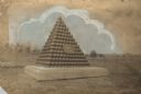
| Description: | Monument marking the place where Colonel Hans Heg was mortally wounded during the Battle of Chickamauga. |

| Date: | |
|---|---|
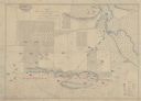
| Description: | A map of southern Wisconsin and northern Illinois showing where the battles took place and routes taken by Black Hawk and his band during the Black Hawk Wa... |

| Date: | 1915 |
|---|---|
| Description: | This 1915 map covers portions of Barron, Chippewa, and Rusk counties in Wisconsin. Shown are the township and range grid, sections, cities and villages, ra... |
| Date: | 12 05 1863 |
|---|---|
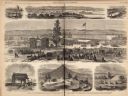
| Description: | Engraving of the dedication ceremony for the Soldiers' National Cemetery, November 19,1863, that appeared in "Frank Leslie's Illustrated Newspaper." It was... |
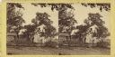
| Date: | 07 1863 |
|---|---|
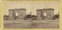
| Description: | Stereograph of the Evergreen Cemetery, a private cemetery in Gettysburg opened in 1855. Because of its location on Cemetery Hill, the highest point in the ... |
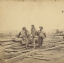
| Date: | 07 1863 |
|---|---|
| Description: | Stereograph of three Confederate soldiers captured during the Battle of Gettysburg. This photograph was taken by Mathew Brady a few days after the battle. ... |
| Date: | 07 1863 |
|---|---|
| Description: | Stereograph of the farmhouse of Abram Bryant, a free black man who lived near Gettysburg, Pennsylvania. An African American man is standing near the porch ... |
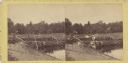
| Date: | 07 1863 |
|---|---|
| Description: | Stereograph of McPherson's Woods, where General John Reynolds, commanding the First Corps of which Wisconsin's 2nd, 6th, and 7th regiments were a part, was... |
If you didn't find the material you searched for, our Library Reference Staff can help.
Call our reference desk at 608-264-6535 or email us at: