 Filter: Categories of Wisconsin Historical Images
Filter: FORMAT_TYPE of prints, photomechanical
Filter: Subject of cities and towns
Filter: Categories of Wisconsin Historical Images
Filter: FORMAT_TYPE of prints, photomechanical
Filter: Subject of cities and towns
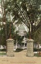
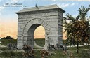
| Date: | 1909 |
|---|---|
| Description: | View of one of the four Prairie du Chien stone gateways that stood at the four corner entrances to the Capitol Park. More elaborate gates topped with iron ... |

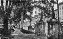
| Date: | 1904 |
|---|---|
| Description: | Postcard depicting the fire of February 26-27, 1904 that destroyed most of the second Wisconsin State Capitol. The smoke and flames have been dramatically ... |

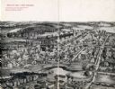
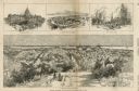
| Date: | 1937 |
|---|---|
| Description: | Bird's-eye view of Milwaukee in 1853 details building features and city layout from southwest. Important buildings are numbered in a silhouette drawing bel... |
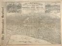
| Date: | 08 28 1889 |
|---|---|
| Description: | Bird's-eye view of Milwaukee, drawn from sketches and photographs for the "Milwaukee Daily Sentinel," with insets of Schlitz Park and the Pabst Brewing Com... |
| Date: | 1912 |
|---|---|
| Description: | This card which is postmarked 1912 shows the zinc statutes on the stone gateways near the sidewalk at Monona Avenue (now Martin Luther King Jr. Blvd.). Ori... |
| Date: | 1909 |
|---|---|
| Description: | Illustration of town. Caption reads: "Bird's-eye View, Lyons, Wisconsin. A Village of natural environments, choice residence locations, desirable factory s... |

| Date: | 1890 |
|---|---|
| Description: | Bird's-eye view of Sheboygan on an advertisement for Kempf's Magical Salve, distributed by E.J. Kempf, "Legitimate Bill Poster and Distributor." |

| Date: | 1855 |
|---|---|
| Description: | Part of George Harrison's "Map of the City of Madison," showing the development of the isthmus and the small size of the second Capitol (54' x 104') in com... |

| Date: | 1896 |
|---|---|
| Description: | A portion of John B. Heim's map of the Water Works System of Madison showing the size of the third Wisconsin Capitol (228' x 226') in comparison with the C... |
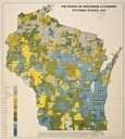
| Date: | 1940 |
|---|---|
| Description: | Map of the people of Wisconsin according to ethnic stocks. |

| Date: | 1905 |
|---|---|
| Description: | Bird's-eye view of Manitowoc on the shores of Lake Michigan. A map of the northeastern part of the United States at the top indicates Manitowoc's location ... |
| Date: | 03 30 1889 |
|---|---|
| Description: | Bird's-eye view from Bascom Hill of Madison, with vignettes of the Wisconsin State Capitol, Lake Monona, and the Capitol Park. |
| Date: | 1912 |
|---|---|
| Description: | Camp Randall Memorial Arch and Civil War cannons. The memorial was built to honor Wisconsin Civil War soldiers and is located on the University of Wisconsi... |
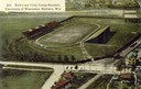
| Date: | 1908 |
|---|---|
| Description: | Aerial view of Camp Randall Stadium on the University of Wisconsin-Madison campus. Top image on Place File card. Caption reads: "Bird's-eye View, Camp Ra... |

| Date: | 1892 |
|---|---|
| Description: | Bird's-eye view of Chicago, with ships in the Lake Michigan harbor. |

| Date: | 1906 |
|---|---|
| Description: | Bird's-eye view of McGregor on the Mississippi River. |

| Date: | 1910 |
|---|---|
| Description: | Colorized view of the Wisconsin Central Railroad depot. Caption reads: "Wisconsin Central R. R. Depot, Ladysmith, Wis." |
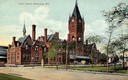
| Date: | 1908 |
|---|---|
| Description: | Union Depot with clock tower. The railroad station with clock tower is behind a park. Horse-drawn vehicles are near the entrance. Caption reads: "Union Dep... |
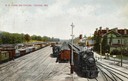
| Date: | 1909 |
|---|---|
| Description: | Elevated view of the railroad yards and station. Caption reads: "R. R. Yards and Station, Portage, Wis." |

| Date: | 1910 |
|---|---|
| Description: | Sawmill on a Menominee Indian reservation, with logs floating in the water in the foreground. Caption reads: "Menominee Indian Mills." |
If you didn't find the material you searched for, our Library Reference Staff can help.
Call our reference desk at 608-264-6535 or email us at: