 Filter: Categories of Wisconsin Historical Images
Filter: FORMAT_TYPE of prints, fine-art
Filter: Subject of war
Filter: Categories of Wisconsin Historical Images
Filter: FORMAT_TYPE of prints, fine-art
Filter: Subject of war

| Date: | 1852 |
|---|---|
| Description: | Illustration of the Ojibwa, the Sacs, and Foxes battling from canoes on the water. |
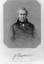
| Date: | 1849 |
|---|---|
| Description: | A portrait of Zachary Taylor, 12th President of the United States, 1849-1850. Born in Virginia on November 24, 1784, Taylor died in office on July 9, 185... |

| Date: | |
|---|---|
| Description: | A portrait of General Grant surrounded with scenes of his life. |

| Date: | |
|---|---|
| Description: | Poster soliciting funds for Metropolitan Madison War Chest. Featured are caricatures of Hitler and Goering. |

| Date: | 1934 |
|---|---|
| Description: | Poster for an anti-war documentary film written by Burnet Hershey and produced by M.J. Kandel for Ideal Pictures Corp. |
| Date: | 1860 |
|---|---|
| Description: | An old woman, stooped over and holding a cane, has Union soldiers ("NORTH" on the left) and Confederate soldiers ("SOUTH" on the right) climbing ladders to... |

| Date: | 1740 |
|---|---|
| Description: | Engraved and hand-colored map of the Iberian peninsula as a theater of war during the War of the Spanish Succession (1701-1714). The map is dedicated to Ki... |

| Date: | 05 1854 |
|---|---|
| Description: | This yellow and black wood block print broadside ties England and France's declaration of war against Russia during the Crimean War into a war against high... |

| Date: | 1950 |
|---|---|
| Description: | This map shows regions in Northern Illinois and Southern Wisconsin roughly bounded by Lake Winnebago, the Kankakee River, Peoria, and Prairie du Chien. The... |

| Date: | 1758 |
|---|---|
| Description: | This detailed map of north eastern America shows the boundaries, cities, mountains, rivers, lakes, Native American land and towns, and roads from east of t... |

| Date: | 1758 |
|---|---|
| Description: | Map showing lakes, rivers, cities, Native American land, and the boundaries of French and English claims in America and Canada north of New York. A title c... |

| Date: | 1755 |
|---|---|
| Description: | Map of colonial America, showing the lands north of South Carolina and west of the Mississippi River. An inset map of the Carolinas and Georgia sits in the... |

| Date: | 1777 |
|---|---|
| Description: | Map of Colonial America east of Lake Michigan showing regions, cities, forts, Native American land, mountains, lakes, and rivers. Crossed swords and small ... |

| Date: | 1795 |
|---|---|
| Description: | Map of the United States east of the Mississippi River. It features roads, cities, towns, early settlements, Native American land, forts, mountains, rivers... |

| Date: | 1755 |
|---|---|
| Description: | Map of New England, with three inset maps of Fort Oswego, Fort du Quesne, and Fort Frederick. It shows colonies, a few cities, forts (marked as French or E... |

| Date: | 1760 |
|---|---|
| Description: | Map showing upstate New York, Lake Ontario, and the St. Lawrence River during the last, decisive battle of the French and Indian War. The main map shows a ... |

| Date: | 10 1776 |
|---|---|
| Description: | Broadside map showing the British invasion of New York city in August and September of 1776. The map shows important cities, forts, roads, hills, mountains... |

| Date: | 1781 |
|---|---|
| Description: | Map of the southern portion of the Chesapeake Bay and surrounding lands. It shows counties, a few cities and towns, forts, roads, islands, topographical fe... |

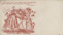
| Date: | 1918 |
|---|---|
| Description: | Hand-drawn poster featuring a woman holding a large stem with flowers draped over her head. She is wearing a hat and dress, as well as wrapped fabric that ... |
If you didn't find the material you searched for, our Library Reference Staff can help.
Call our reference desk at 608-264-6535 or email us at: