 Filter: Categories of Wisconsin Historical Images
Filter: Type of Map or Atlas
Filter: Categories of Wisconsin Historical Images
Filter: Type of Map or Atlas

| Date: | 1946 |
|---|---|
| Description: | This colored road map shows automobile roads in Wisconsin as well as portions of nearby states. Information on the quality and type of any road shown (Inte... |

| Date: | 1938 |
|---|---|
| Description: | This colored road map shows automobile roads in Wisconsin as well as portions of nearby states. Along the bottom edge of the front page, smaller road maps ... |

| Date: | 1892 |
|---|---|
| Description: | A Sanborn map of St. Louis, which is six miles southwest of South Superior. |

| Date: | 1934 |
|---|---|
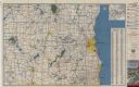
| Description: | This road map contains automobile routes for the state of Wisconsin as well as portions of Minnesota, Illinois, Iowa and Michigan. Lake Michigan, Lake Sup... |
| Date: | 12 1899 |
|---|---|
| Description: | A Sanborn map of Sharon, featuring downtown businesses. |

| Date: | 1910 |
|---|---|
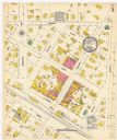
| Description: | A Sanborn insurance map of a section of Milwaukee, including East Clybourn and East Buffalo Streets. "Italian Section 3/4/30" is written on the page in blu... |

| Date: | 1911 |
|---|---|
| Description: | A plat map of the township of Westport in Dane County. |
| Date: | 1879 |
|---|---|
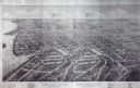
| Description: | Bird's-eye map of Beaver Dam. |

| Date: | 1881 |
|---|---|
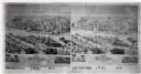
| Description: | Bird's-eye view of Appleton. |
| Date: | 1881 |
|---|---|
| Description: | Bird's-eye map of Kaukauna, with four insets. |

| Date: | 1890 |
|---|---|
| Description: | Plat map of the south part of Caledonia in Columbia County. |

| Date: | 1890 |
|---|---|
| Description: | Portion of the plat map of the north part of Caledonia in Columbia County, including explanations. |

| Date: | 1873 |
|---|---|
| Description: | Map of the township of Windsor, from the "Atlas of Dane County." |
| Date: | 1955 |
|---|---|
| Description: | This colored road map shows automobile roads in Southeastern Wisconsin on the front and Milwaukee on the back. On the front side of the map, information on... |

| Date: | 1955 |
|---|---|
| Description: | This colored road map shows automobile roads in Wisconsin as well as portions of nearby states. Information on the quality and type of any road shown (U.S.... |
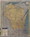
| Date: | 1951 |
|---|---|
| Description: | This colored road map shows automobile roads in Wisconsin as well as portions of nearby states. Information on the quality and type of any road shown (pave... |

| Date: | |
|---|---|
| Description: | This colored road map shows automobile roads in Wisconsin as well as portions of nearby states. Information on the quality and type of any road shown (pave... |
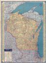
| Date: | 1937 |
|---|---|
| Description: | This colored road map shows automobile roads in Wisconsin as well as portions of nearby states. Information on the quality and type of any road shown (pave... |

| Date: | 1936 |
|---|---|
| Description: | This colored road map shows automobile roads in Wisconsin as well as portions of nearby states. Information on the quality and type of any given road (pave... |
If you didn't find the material you searched for, our Library Reference Staff can help.
Call our reference desk at 608-264-6535 or email us at:
