 Search: War
Filter: Categories of Wisconsin Historical Images
Filter: Year of 1800-1899
Filter: Year of 1850-1859
Search: War
Filter: Categories of Wisconsin Historical Images
Filter: Year of 1800-1899
Filter: Year of 1850-1859
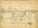
| Date: | 1856 |
|---|---|
| Description: | An original illustration of the lock at Rexford Flats. |
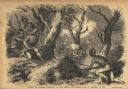
| Date: | 01 07 1855 |
|---|---|
| Description: | Sketch of the defeat of General Braddock during an ambush in the French and Indian War. Caption reads: "Defeat of General Braddock, in the French and India... |

| Date: | 1858 |
|---|---|
| Description: | Portrait of William Freeman Vilas (1840-1908), Civil War and United States Senator, taken while he was a student at the University of Wisconsin. |
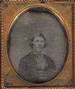
| Date: | 1850 |
|---|---|
| Description: | Sixth plate daguerreotype of Captain Joseph Dickson, waist-up, facing front and slightly towards the right. Dickson fought in the Black Hawk War in 1832. |
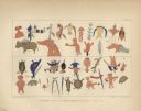
| Date: | 1851 |
|---|---|
| Description: | Pictorial record of a Chief's Success in Hunting and War displayed in pictographs. Two rows of symbols including animals, human figures and plants. |
| Date: | 1858 |
|---|---|
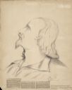
| Description: | Original sketch drawn by Col. Elmer E. Ellsworth in 1858 at Madison, Wisconsin, and presented to N.B. Van Slyke. Col. Ellsworth commanded the 1st Zouaves a... |

| Date: | 05 1854 |
|---|---|
| Description: | This yellow and black wood block print broadside ties England and France's declaration of war against Russia during the Crimean War into a war against high... |
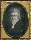
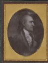
| Date: | 1850 |
|---|---|
| Description: | Ninth plate daguerreotype of a painted quarter-length portrait of Felix Walker, 1793-1828. Mr. Walker fought in the Revolutionary War alongside Daniel Boon... |

| Date: | 1859 |
|---|---|
| Description: | Portrait of Cassius Fairchild of Madison, the eldest son of Jairus Fairchild, about 1859. At this time he assumed responsibility for a large part of the fa... |
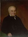
| Date: | 1859 |
|---|---|
| Description: | Oil portrait of Nathaniel Ames, a former Revolutionary War soldier. |
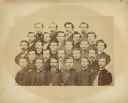
| Date: | 1859 |
|---|---|
| Description: | Typed text on back of photograph: "River Falls Rifle company, River Falls, Wis. Organized 1859, later fought with 12th Wisconsin Volunteer Regiment in Civi... |
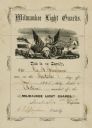
| Date: | 06 30 1855 |
|---|---|
| Description: | Certificate of appointment for George B. Bingham as 1st Lieutenant, Milwaukee Light Guards. |
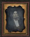
| Date: | 1855 |
|---|---|
| Description: | An eighth plate daguerreotype of Edward P. Bridgman, 1834-1915, as a young man. Bridgman served in the 37th Massachusetts volunteer Infantry, Company G in ... |
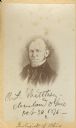
| Date: | 1858 |
|---|---|
| Description: | Carte-de-visite portrait of Charles Whittlesey (1808-1886), American Geologist. Fought in the Black Hawk War. Opened a law office and newspaper in Clevelan... |

| Date: | 1856 |
|---|---|
| Description: | This landscape painting by Samuel Marsden Brookes and Thomas H. Stevenson depicts a broad view of the confluence of Bad Axe and Mississippi Rivers; site of... |
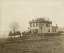
| Date: | 1855 |
|---|---|
| Description: | Early view of the house built by Madison's first mayor, Jairus C. Fairchild, at 302 South Wisconsin Avenue (renamed Monona Avenue in 1877) at West Wilson S... |

| Date: | 1855 |
|---|---|
| Description: | Map reads "Our Country" which is accompanied by a sailor with a flag to the left and workers rejoicing under the Constitution and Laws to the right. Across... |
| Date: | 1850 |
|---|---|
| Description: | Quarter plate daguerreotype of a painting of Colonel Robert Patterson (1753-1827). Patterson was a pioneer settler to both Kentucky and Ohio. He served in ... |

| Date: | 1852 |
|---|---|
| Description: | Illustration of the Ojibwa, the Sacs, and Foxes battling from canoes on the water. |

| Date: | 1858 |
|---|---|
| Description: | This map shows the depth of the West Channel and the different types of minerals that make up the floor bed. The steamboat range station is labeled. A note... |
If you didn't find the material you searched for, our Library Reference Staff can help.
Call our reference desk at 608-264-6535 or email us at: