 Search: War
Filter: Categories of Wisconsin Historical Images
Filter: Subject of international relations
Search: War
Filter: Categories of Wisconsin Historical Images
Filter: Subject of international relations
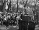
| Date: | 10 24 1950 |
|---|---|
| Description: | Corporal Albert Griffin, a soldier from Milwaukee wounded in the Korean War, addressing the crowd gathered at the Wisconsin State Capitol on United Nations... |
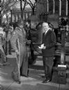
| Date: | 10 24 1950 |
|---|---|
| Description: | Corporal Albert Griffin, a soldier from Milwaukee wounded in the Korean War, standing with Governor Rennebohm at the freedom bell during ceremonies at the ... |

| Date: | 01 24 1947 |
|---|---|
| Description: | William Bross Lloyd Jr., World War II conscientious objector, who is visiting Wisconsin to promote a U.S. Constitutional Convention to amend the Constituti... |
| Date: | 1947 |
|---|---|
| Description: | John J. McCoy, U.S. Commissioner in Germany being interviewed by Mutual news analyst Cecil Brown. Brown made his reputation during the post-World War II ye... |

| Date: | 1777 |
|---|---|
| Description: | Map of Colonial America east of Lake Michigan showing regions, cities, forts, Native American land, mountains, lakes, and rivers. Crossed swords and small ... |

| Date: | 03 30 1971 |
|---|---|
| Description: | A centerfold of an anti-war newspaper which promotes "A Treaty of Peace Between 2 Peoples." Features two photographs of American and Vietnamese citizens an... |

| Date: | 10 30 1965 |
|---|---|
| Description: | Critics and supporters of the United States policy in Viet Nam discuss their views at a meeting of the policy committee of the University of Wisconsin Youn... |

| Date: | 1780 |
|---|---|
| Description: | Map of North America east of Mexico showing colonial boundaries, forts, cities, Native American land, mountains, waterfalls, lakes, and rivers. Short notes... |

| Date: | 1763 |
|---|---|
| Description: | Map of America and part of Canada including the borders of European claims after the French and Indian War. Cities, forts, Native American lands, rivers, l... |

| Date: | 09 1944 |
|---|---|
| Description: | Prime Minister Winston Churchill greets President Franklin Roosevelt as he is about to exit his vehicle for their meeting at Quebec. This was their second ... |

| Date: | 02 13 1950 |
|---|---|
| Description: | The University of Wisconsin Dames Club has a number of war brides from foreign countries who have gravitated to the international relations group. Mrs. Ke... |

| Date: | 1765 |
|---|---|
| Description: | Detailed map composed for the London Magazine of the Mississippi River Valley at the conclusion of the French and Indian War. The British colonies themselv... |

| Date: | 1755 |
|---|---|
| Description: | This map shows the eastern half of North America during the French and Indian war, including cities, borders, Native American Land, forts, and detailed geo... |

| Date: | 1758 |
|---|---|
| Description: | Map showing lakes, rivers, cities, Native American land, and the boundaries of French and English claims in America and Canada north of New York. A title c... |

| Date: | 1770 |
|---|---|
| Description: | Map of North America showing the boundaries between French, Spanish, and English claims after the French and Indian War. Kitchin includes numerous place na... |
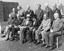
| Date: | 09 1944 |
|---|---|
| Description: | British and American combined Chiefs of Staff led by Prime Minister Winston Churchill and President Franklin D. Roosevelt. The conference was held in Quebe... |
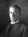
| Date: | 1890 |
|---|---|
| Description: | Studio portrait of Magnus Swenson. He was a Norwegian immigrant who made his name in business and as an inventor. He served on the Wisconsin Capitol Buildi... |

| Date: | 1776 |
|---|---|
| Description: | Map showing the English claims in America at the outbreak of the Revolutionary War. Lotter labels each of the thirteen colonies (both in the map and in the... |

| Date: | 1766 |
|---|---|
| Description: | This map of North America shows the boundaries of European claims at the end of the French and Indian war. The British colonies extend to the Mississippi. ... |
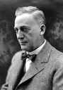
| Date: | 1900 |
|---|---|
| Description: | Studio portrait of Magnus Swenson. He was a Norwegian immigrant who made his name in business and as an inventor. He served on the Wisconsin Capitol Buil... |
If you didn't find the material you searched for, our Library Reference Staff can help.
Call our reference desk at 608-264-6535 or email us at: