 Search: LIGHTHOUSES
Filter: Year of 1900-1999
Search: LIGHTHOUSES
Filter: Year of 1900-1999

| Date: | 1909 |
|---|---|
| Description: | This 1909 chart of the Apostle Islands, Chequamegon Bay, and the Lake Superior shoreline shows relief by contours and spot heights and depths by contours, ... |

| Date: | 1950 |
|---|---|
| Description: | This map of Sturgeon Bay is part of the survey of the northern and northwestern lakes. The map shows lights, railroads, roads, and some public buildings. R... |

| Date: | 1941 |
|---|---|
| Description: | Elevated view of Sturgeon Bay in 1900. Sturgeon Bay Bridge spans the bay and several boats are on the water. A lighthouse sits on a small island in the bay... |

| Date: | 1905 |
|---|---|
| Description: | This map shows railroads, towns, lights, lights to be established, fog signals, light-vessels, lighted buoys, light-house depots, and light-house reservati... |

| Date: | 1967 |
|---|---|
| Description: | This colored map published by the State Historical Society of Wisconsin shows key points of interest telling the story of Wisconsin's earliest settlement a... |

| Date: | 1930 |
|---|---|
| Description: | Text on front reads: "Life Saving Station, Racine, Wis." Located at the mouth of the Root River, the Life Saving Station is the white structure. It was add... |

| Date: | 1957 |
|---|---|
| Description: | Large Letter style postcard for Green Bay depicting various scenes in the letters that spell the name of the city. Caption reads: "Greetings from Green Bay... |

| Date: | 1908 |
|---|---|
| Description: | This map shows railroads, towns, lights, lights to be established, fog signals, light-vessels, lighted buoys, light-house depots, and light-house reservati... |
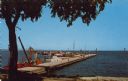
| Date: | 1958 |
|---|---|
| Description: | Text on reverse reads: "Yacht Basin on Lake Michigan. Sheboygan, Wisconsin." View from shore towards a long "L" shaped concrete dock with many boats moored... |
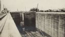
| Date: | 03 1913 |
|---|---|
| Description: | An unidentified man in light-colored uniform, on the far left just behind a column, is standing atop the near side of the Gatun Locks near Colon, Panama. O... |
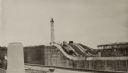
| Date: | 03 1913 |
|---|---|
| Description: | A view looking toward the Atlantic entrance to the Panama Canal, over the Gatun Locks during construction. The entrance lighthouse is seen in the distance.... |

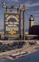
| Date: | 1963 |
|---|---|
| Description: | Text on front reads: "Wisconsin's North Coast." A man is standing on the side deck of a boat, and in the distance is the Raspberry Island Lighthouse with a... |
| Date: | 1973 |
|---|---|
| Description: | Text on sign reads: "Lighthouse on the Lake, Motel, Restaurant, Indoor Pool." On reverse: "Lighthouse Inn on the Lake. Highway 42, 1515 Memorial Drive, Two... |

| Date: | 04 1926 |
|---|---|
| Description: | This blueprint mostly shows various numbers within the canal and bay. Lake Michigan and Harobor of Refuge are shown along the far right side. Near the harb... |
| Location: | Barker's Island Marina 250 Marina Dr |
|---|---|
| Nearby City: | Superior, Douglas County |
| Body of water: | Lake Superior |
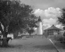
| Date: | 1905 |
|---|---|
| Description: | View along a sandy pathway toward the Amelia Island lighthouse near the keeper's house. Trees line the pathway, and two horses pulling a carriages are on t... |
| Location: | Ashland breakwater |
|---|---|
| Nearby City: | Ashland, Ashland County |
| Body of water: | Lake Superior |

| Activities, vocabulary, discussion questions, and extensions for using Sport with your students. |
|---|
| Discussion guide intended for use with Sport: Ship Dog of the Great Lakes. |
If you didn't find the material you searched for, our Library Reference Staff can help.
Call our reference desk at 608-264-6535 or email us at: