 Search: Bureau
Search: of
Filter: Categories of Wisconsin Historical Images
Filter: Year of 1800-1899
Search: Bureau
Search: of
Filter: Categories of Wisconsin Historical Images
Filter: Year of 1800-1899

| Date: | 1899 |
|---|---|
| Description: | This color map, originally published in the Smithsonian Institution Bureau of American Ethnology's 18th annual report, shows the Indian land cessions in Wi... |

| Date: | 1835 |
|---|---|
| Description: | Constructed for the Topographical Bureau [Wash.], 1835. Scale: 16 miles to 1 inch. Map of a portion of the Indian country lying east and west of the Missis... |

| Date: | 1833 |
|---|---|
| Description: | Map of part of the military road from Fort Crawford to Fort Howard. "Recorded on pages 668.669 Book B." Surveyed by Lieut. Center. Scale: 2 miles = 1 inch. |
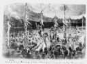
| Date: | 1874 |
|---|---|
| Description: | Copy photograph of a painting of a Sioux Sun Dance ritual. Painting by Jules Tavernier. |

| Date: | 1899 |
|---|---|
| Description: | This map shows color coded and numbered regions of Indian land cessions. Lake Superior and Lake Michigan are labeled and other lakes and rivers are shown. ... |

| Date: | 1857 |
|---|---|
| Description: | Information depicting the history, condition and prospects of the Indian tribes of the United States: collected and prepared under the direction of the Bur... |

| Date: | 1864 |
|---|---|
| Description: | This battlefield map of the Battle of Totopotomoy Creek, also known as the Battle of Bethesda Church, shows the railroads, roads, vegetation and topography... |
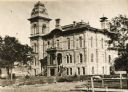
| Date: | 1875 |
|---|---|
| Description: | View of the courthouse. Roof and lower part have since been changed. |
| Date: | 1865 |
|---|---|
| Description: | Elevated view of the fort, with snow on the ground. |

| Date: | 1889 |
|---|---|
| Description: | Ticket for the inauguration of President Benjamin Harrison. This ticket belonged to William Freeman Vilas of Wisconsin, the Secretary of the Interior. The ... |

| Date: | 1899 |
|---|---|
| Description: | This map shows color coded and numbered regions of Indian land cessions. Lake Superior and Lake Michigan are labeled and other lakes and rivers are shown. ... |
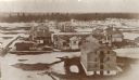
| Date: | 05 30 1889 |
|---|---|
| Description: | View of the Chippewa Lumber and Boom Company's Big Mill beyond the Wagon Bridge over the Chippewa River. |

| Date: | 1862 |
|---|---|
| Description: | The second in a series of three maps of the Virginia Peninsula. This map details the area from Williamsburg north to West Point. |

| Date: | 1835 |
|---|---|
| Description: | Little Lake Butte Des Morts just north of Lake Winnebago where Governor Lewis Cass of Michigan, and Thomas McKenney, head of the Bureau of Indian Affairs (... |

| Date: | 1862 |
|---|---|
| Description: | The third in a series of three maps of the Virginia Peninsula. This map details the area from Harrison's Landing west to Richmond and shows troop positions... |
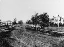
| Date: | 1870 |
|---|---|
| Description: | View of dirt road with houses along both sides, and wooden walkways and picket fences along the road. |

| Date: | 1862 |
|---|---|
| Description: | The first in a series of three maps of the Virginia Peninsula. This map details the area from Williamsburg south to Fortress Monroe at Hampton Roads and sh... |

| Date: | 1897 |
|---|---|
| Description: | A map of Wisconsin showing the self-supporting churches, Home Missionary churches, stations not organized, Sunday schools of C.S.S. Society, Congregational... |
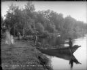
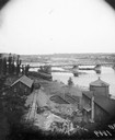
| Date: | 1899 |
|---|---|
| Description: | View along shoreline towards Indian log drivers, two in a bateau, and one man standing on the bank of the Chippewa River. |
If you didn't find the material you searched for, our Library Reference Staff can help.
Call our reference desk at 608-264-6535 or email us at:
