 Filter: Year of 1700-1799
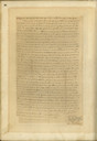
| Date: | 06 19 1775 |
|---|---|
| Description: | The second page of a letter written to Col. William Preston from Thomas Lewis. From Preston and Virginia Papers [Calendar series Volume 1]: "Letter ... |
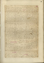
| Date: | 08 11 1781 |
|---|---|
| Description: | The front page of a letter written by Thomas Lewis to William Preston. From Preston and Virginia Papers [Calendar series Volume 1]: "Rockingham. Let... |
| Date: | 08 1781 |
|---|---|
| Description: | The second page of a letter written by Thomas Lewis to Col. William Preston. From Preston and Virginia Papers [Calendar series Volume 1]: "Rockingha... |

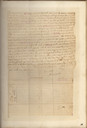
| Date: | 08 31 1779 |
|---|---|
| Description: | A handwritten "list of different inhabitants that consented to furnish the troops belonging to the state of Virginia." |

| Date: | 1760 |
|---|---|
| Description: | This map shows lakes, rivers, forts, settlements, and Native American tribal territory. The southern boundary of the Hudsons Bay Company is labeled. Relief... |
| Date: | 1792 |
|---|---|
| Description: | This map depicts the fixed boundaries by a peace treaty between the United States and the Spanish Dominions. |

| Date: | 1760 |
|---|---|
| Description: | A map of the world in two hemispheres, with the borders of the continents hand-colored. This map contains 14 spherical diagrams of the cosmos, portraying t... |

| Date: | 1715 |
|---|---|
| Description: | A map of the countries and islands surrounding the Gulf of Mexico. The hand-colored borders separate the territories of England, France, Spain, and Holland... |

| Date: | 1721 |
|---|---|
| Description: | A map of North and South America with an elaborately illustrated cartouche depicting Native Americans in upper left corner. The map is fairly detailed, dep... |

| Date: | 1735 |
|---|---|
| Description: | A map of the western hemisphere, including parts of western Europe and Africa. Portraits of explorers, such as Jacques Marquette, Louis Joliet, and Robert ... |

| Date: | 1739 |
|---|---|
| Description: | This map shows the territorial claims of the western hemisphere by the European powers, as well as the names of major cities, geographical features, and pa... |

| Date: | 1746 |
|---|---|
| Description: | A map of the western hemisphere, including parts of western Europe and Africa, showing the division of the Americas by the European powers. Weapons and fol... |

| Date: | 1761 |
|---|---|
| Description: | This map shows the western hemisphere. Much of the north-west coast of North America is left blank, but the rest of the map lists the names of rivers, citi... |

| Date: | 1786 |
|---|---|
| Description: | This map is an updated version of d'Anville's 1761 map of the western hemisphere. He included more details to the north west coast of North America, partic... |

| Date: | 1710 |
|---|---|
| Description: | A seminal and fairly accurate map of the Great Lakes Region up to Baffin's Bay in Northern Canada. This is possibly the first printed map to locate Detroit... |

| Date: | 1703 |
|---|---|
| Description: | Map of the Golf of Mexico and surrounding countries from the Great Lakes down to the northern most parts of South America. L'Isle labels cities, towns, and... |

| Date: | 1720 |
|---|---|
| Description: | One of Herman Moll's most famous maps, often referred to as The Beaver Map for its elaborate engraved inset depicting and describing beavers building a dam... |

| Date: | 1715 |
|---|---|
| Description: | One of Herman Moll's most famous maps, often referred to as The Codfish Map, it shows rivers and portages, cities, Indian villages, wind directions, routes... |

| Date: | 1718 |
|---|---|
| Description: | This map shows the Mississippi River, with latitude and longitude coordinates, ad covers east to Lake Ontario and south to Illinois. The inset map (the top... |

| Date: | 1719 |
|---|---|
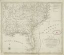
| Description: | Map of the British colonies and territories in North American, depicting cities, Native American land, rivers, mines, forts, trees, and topography east of ... |
If you didn't find the material you searched for, our Library Reference Staff can help.
Call our reference desk at 608-264-6535 or email us at: