Filter: Subject of Engraving
Filter: Subject of social issues
Filter: Subject of Engraving
Filter: Subject of social issues
| Date: | 02 1892 |
|---|---|
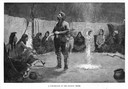
| Description: | Engraving of a fur trader standing in the middle of a circle of seated Indians in their council tepee. |
| Date: | 1884 |
|---|---|
| Description: | A engraving of the artist's conception of Pawnees torturing a female captive in the Morning Star Sacrifice ceremony. |

| Date: | |
|---|---|
| Description: | "Death Whoop" an engraving after a drawing by Seth Eastman from the American Aboriginal Portfolio. |
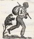
| Date: | 1837 |
|---|---|
| Description: | Image of a runaway slave with stick and satchel. |

| Date: | 06 24 1969 |
|---|---|
| Description: | Cover of "The Kudzu," an underground newspaper, featuring a reproduction of Martin Schongauer's 15th Century engraving entitled, "Saint Anthony Tormented b... |
| Date: | 02 1932 |
|---|---|
| Description: | Engraving by Charles Silver to mark the passage of Wisconsin's Unemployment Compensation Law, the first in the nation. |
| Date: | 04 05 1862 |
|---|---|
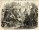
| Description: | Group of Confederate prisoners of war assembled in prison barracks. |
| Date: | 06 12 1858 |
|---|---|
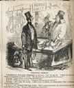
| Description: | A political cartoon in "Harper's Weekly" about railroad company presidents' purchasing Wisconsin state legislatures and governors. The caption reads: ... |
| Date: | 1858 |
|---|---|
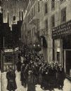
| Description: | Large group of people leaving a steam ship, some transporting large chests of their belongings. |
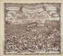
| Date: | 1819 |
|---|---|
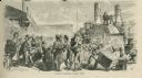
| Description: | A commemorative handkerchief created by a wood engraving on white cotton fabric. The scene is the Manchester Reform Meeting, in England. A crowd of demonst... |
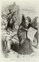
| Date: | 02 17 1872 |
|---|---|
| Description: | Political cartoon depicting a woman on a rocky path carrying two children and a drunken husband on her back being tempted by Victoria Woodhull depicted as ... |

| Date: | 1783 |
|---|---|
| Description: | This map is hand-colored and shows the boundaries of British, Spanish, and the newly recognized American claims, as well as the fishing rights granted to F... |

| Date: | 1770 |
|---|---|
| Description: | The south west sheet of a four sheet map of Virginia, showing the counties, mountains, rivers, court houses, a few cities, and mills. A few Plantations ar... |

| Date: | 1780 |
|---|---|
| Description: | This map shows the townships, parishes, cities, towns, plantations, lakes, rivers, swamps, and roads near the coast of South Carolina and Georgia. Emphasis... |

| Date: | 1755 |
|---|---|
| Description: | Map of Virginia and parts of Maryland, North Carolina, and New Jersey. It shows borders, boundary lines, some Native American land, counties, cities, towns... |
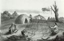
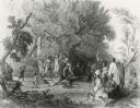
| Date: | 1884 |
|---|---|
| Description: | A completed Chippewa (Ojibwa) lodge and a lodge under construction. A Native American woman is stitching something on the completed lodge. Another Native A... |
If you didn't find the material you searched for, our Library Reference Staff can help.
Call our reference desk at 608-264-6535 or email us at: