Filter: Categories of Wisconsin Historical Images
Filter: State of New York
Filter: Subject of engraving
Filter: Categories of Wisconsin Historical Images
Filter: State of New York
Filter: Subject of engraving
| Date: | |
|---|---|
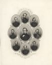
| Description: | Jefferson Davis, center, surrounded by, clockwise from the top: Confederate Generals Robert E. Lee, A.P. Hill, J.E.B. Stuart, Braxton Bragg, Joseph E. John... |

| Date: | 1900 |
|---|---|
| Description: | A group of immigrants, both children and adults, who have just arrived at Ellis Island. |
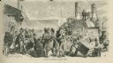
| Date: | 1858 |
|---|---|
| Description: | Large group of people leaving a steam ship, some transporting large chests of their belongings. |

| Date: | 1856 |
|---|---|
| Description: | Engravings of the Presidential and Vice-Presidential candidates from the Democratic, Republican and Know Nothing parties for the Tuesday, November 4th, 185... |
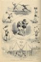
| Date: | 12 1875 |
|---|---|
| Description: | Composite of engraved images of men involved in various athletic activities: fencing, weightlifting, juggling with clubs and cannon balls, wrestling, and b... |

| Date: | 02 13 1869 |
|---|---|
| Description: | Engraved image of several men attempting to ride velocipedes in a large open, interior space. Many have fallen or are struggling with balance. |
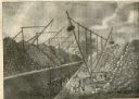
| Date: | 1825 |
|---|---|
| Description: | Engraved view of several wooden cranes extracting large stones from a cut during the construction of the Erie Canal. The rig in the foreground is horse-dri... |
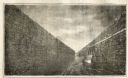
| Date: | 1825 |
|---|---|
| Description: | Engraved view of boats being towed by horses through the Erie Canal at Lockport Erie Canal at Lockport. The horses can be seen on a high towpath at right. ... |
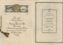
| Date: | 02 25 1926 |
|---|---|
| Description: | Front cover and menu listing from the booklet printed for the Forty-ninth Annual Dinner of the American Paper and Pulp Association at the Waldorf Astoria H... |

| Date: | 1777 |
|---|---|
| Description: | Map showing the Hudson River in three sections, from New York City up through Lake Champlain, including cities, forts, roads, topographical features, and n... |

| Date: | 1780 |
|---|---|
| Description: | Map of New York and parts of the neighboring states. It shows cities, forts, towns, roads, mountains, lakes, and rivers. several different boundary lines a... |

| Date: | 1760 |
|---|---|
| Description: | Map showing upstate New York, Lake Ontario, and the St. Lawrence River during the last, decisive battle of the French and Indian War. The main map shows a ... |

| Date: | 1795 |
|---|---|
| Description: | Detailed map of New York, showing counties, cities, mines, mills, roads, swamps, mountains, lakes and rivers. The map also shows Native American towns and ... |

| Date: | 1778 |
|---|---|
| Description: | Map of the land between Fort Ticonderoga and Albany. It shows cities, forts, mills, roads, mountains, swamps, waterfalls, lakes, and rivers. A few annotati... |

| Date: | 10 1776 |
|---|---|
| Description: | Broadside map showing the British invasion of New York city in August and September of 1776. The map shows important cities, forts, roads, hills, mountains... |

| Date: | 02 1777 |
|---|---|
| Description: | Map depicting the campaigns of October and November 1776, in Manhattan, Westchester, and part of New Jersey, published only a few months after the conclusi... |

| Date: | 03 1777 |
|---|---|
| Description: | Map showing the British and Hessian attack on Fort Washington in November of 1776. The movements and fortifications of the British and Hessian troops appea... |

| Date: | 11 1781 |
|---|---|
| Description: | Map of New York, Staten Island, and Long Island, showing the placements of forts, and the movement of troops in 1776. The map also includes towns, cities, ... |

| Date: | 1789 |
|---|---|
| Description: | Map of New York City showing ward boundaries, ferries, streets, roads, swamps, ponds, and rivers. The properties of Lispinard, Byards, Jones, Rutgers, and ... |
If you didn't find the material you searched for, our Library Reference Staff can help.
Call our reference desk at 608-264-6535 or email us at: