 Filter: Categories of Wisconsin Historical Images
Filter: Subject of indians of north america
Filter: Subject of waterfalls
Filter: Categories of Wisconsin Historical Images
Filter: Subject of indians of north america
Filter: Subject of waterfalls
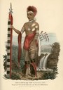
| Date: | 1835 |
|---|---|
| Description: | Kee-o-kuck, or the Watching Fox, a Chief of the Sauk tribe and sucessor to Black Hawk. Hand-colored lithograph from the Aboriginal Portfolio, painted at th... |
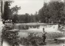
| Date: | 1929 |
|---|---|
| Description: | Group of people at Bear Trap Falls in the Wolf River near Keshena. People are standing on the shoreline on the left near a sign for the falls. A man is sta... |

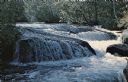
| Date: | 1936 |
|---|---|
| Description: | View across Rainbow Falls on the Wolf River, on the Menominee Indian Reservation. |

| Date: | 1936 |
|---|---|
| Description: | A view of Big Smoky Falls on the Wolf River, on the Menominee Reservation. |

| Date: | |
|---|---|
| Description: | A map of the western Upper Peninsula of Michigan and Wisconsin north of Lake Winnebago and east of Lake Pepin and the mouth of the Saint Louis River on Lak... |

| Date: | 1846 |
|---|---|
| Description: | This map shows the plotting of the various townships in Wisconsin, both those that had been surveyed and some outlines for those which have not. A note in ... |

| Date: | 1758 |
|---|---|
| Description: | This map of the north-west hemisphere shows the cities, lakes, rivers, mountains, and political borders. In the upper left corner sits a decorative cartouc... |

| Date: | 1783 |
|---|---|
| Description: | This map is hand-colored and shows the boundaries of British, Spanish, and the newly recognized American claims, as well as the fishing rights granted to F... |

| Date: | 1790 |
|---|---|
| Description: | This map of the north eastern states shows roads, rivers, lakes, waterfalls, mountains, cities, forts, mills, the Oneida Reservation, and "New York Donatio... |

| Date: | 1766 |
|---|---|
| Description: | This map of North America shows the boundaries of European claims at the end of the French and Indian war. The British colonies extend to the Mississippi. ... |

| Date: | 1760 |
|---|---|
| Description: | Map showing upstate New York, Lake Ontario, and the St. Lawrence River during the last, decisive battle of the French and Indian War. The main map shows a ... |

| Date: | 1756 |
|---|---|
| Description: | Map of Pennsylvania, showing cities, towns, roads, trading paths, portages, forts, mountains, swamps, waterfalls, lakes, and rivers. The map further includ... |

| Date: | 1762 |
|---|---|
| Description: | Map of Virginia and parts of Maryland. It shows borders, boundary lines, Native American tribes and land, towns, forts, roads, mountains, waterfalls, bays,... |

| Date: | 1760 |
|---|---|
| Description: | Map showing the towns, mountains, valleys, corn fields, and rivers of a portion of the Cherokee Nation. A few annotations on the map explain the land and r... |

| Date: | 1755 |
|---|---|
| Description: | Map of the Great Lakes region during the French and Indian War. It shows in great detail the territories, borders and boundary lines, Native American tribe... |
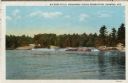
| Date: | 1953 |
|---|---|
| Description: | View upriver across water towards the Big Eddy Falls on the Wolf River. A group of people are standing on the right bank. Caption reads: "Big Eddy Falls, M... |
| Date: | |
|---|---|
| Description: | Caption on back reads: "Neopit, Wis. Menominee Indian rocky outcroppings . . . winding falls . . . nature trail." |

| Date: | 1907 |
|---|---|
| Description: | Text on front reads: "Souvenir Folder, Menominee Indian Girl at Keshena Falls, Shawano, Wisconsin." She is sitting on a rock, posing in a blanket and indi... |
If you didn't find the material you searched for, our Library Reference Staff can help.
Call our reference desk at 608-264-6535 or email us at: