 Filter: Categories of Wisconsin Historical Images
Filter: Subject of indians of north america
Filter: County of Crawford
Filter: Categories of Wisconsin Historical Images
Filter: Subject of indians of north america
Filter: County of Crawford
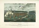
| Date: | 09 1825 |
|---|---|
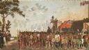
| Description: | Treaty at Prairie du Chien, with Fort Crawford seen in the background. This treaty negotiated between Governor William Clark and Governor Lewis Cass and ov... |
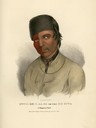
| Date: | 1825 |
|---|---|
| Description: | Kitch-ee-i-aa-ba, or the Big Buck, a Chippewa (Ojibwa) Chief. Hand-colored lithograph from the Aboriginal Portfolio, painted at the treaty of Prarie du Chi... |
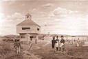
| Date: | 1940 |
|---|---|
| Description: | Photograph of a painting by Cal Peters depicting construction of the first Fort Crawford at Prairie du Chien, Wisconsin in 1816. In the painting, several o... |
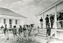
| Date: | 1940 |
|---|---|
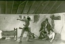
| Description: | Photograph of a painting by Cal Peters depicting the surrender of Black Hawk at Fort Crawford in 1832. |
| Date: | 1940 |
|---|---|
| Description: | Photograph of a painting by Cal Peters depicting the Winnebago attack on the Gagnier homestead in 1827 and the killing of Registre Gagnier. The homestead w... |
| Date: | |
|---|---|
| Description: | Diorama in the Milwaukee Public Museum depicting Black Hawk's surrender on August 27, 1832 at Fort Crawford in Prairie du Chien. |
| Date: | |
|---|---|
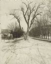
| Description: | The Black Hawk Tree growing in the middle of the street, now East Black Hawk Avenue. There are houses on the left and the road is lined with trees planted... |
| Date: | 1823 |
|---|---|
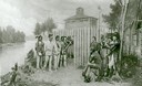
| Description: | British evacuation of their fort at Prairie du Chien after the end of the War of 1812. Fort Shelby, the first fort at Prairie du Chien, was built in 1814 b... |

| Date: | 1838 |
|---|---|
| Description: | This map is a development plat that shows street names, numbered blocks and lots, and small farm lot owners. Included on the right of the map is a large am... |

| Date: | |
|---|---|
| Description: | This map is pen-and-ink on tracing paper with a mounted legend and shows the Kickapoo River, Indian mounds, the 1st Fort Crawford, an Indian Agency, the si... |

| Date: | 1900 |
|---|---|
| Description: | This map shows a line, marked with latitude and longitude coordinates that runs through Prairie du Chien. Only a few features beyond this line are displaye... |
If you didn't find the material you searched for, our Library Reference Staff can help.
Call our reference desk at 608-264-6535 or email us at: