Filter: Categories of Wisconsin Historical Images
Filter: Subject of indians of north america
Filter: County of Calumet
Filter: Categories of Wisconsin Historical Images
Filter: Subject of indians of north america
Filter: County of Calumet
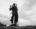
| Date: | 1963 |
|---|---|
| Description: | Statue of Winnebago Indian Chief Red Bird, with Lake Winnebago in the background. |
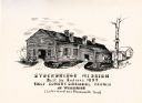
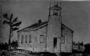
| Date: | 1910 |
|---|---|
| Description: | Exterior view of the Stockbridge Indian Mission, built in about 1834, with several figures and a horse standing in the structure's doorway. |
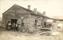
| Date: | 1913 |
|---|---|
| Description: | Exterior view of the Stockbridge Indian Mission with men standing near its entrance. |
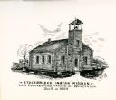
| Date: | 1835 |
|---|---|
| Description: | Drawing of the Stockbridge Indian Mission, built in about 1834. |
| Date: | 1835 |
|---|---|
| Description: | Drawing of the Stockbridge Indian mission. |
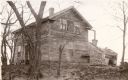
| Date: | |
|---|---|
| Description: | View of the dwelling of Cutting Marsh, missionary to the Stockbridge Indians. |
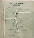
| Date: | 1893 |
|---|---|
| Description: | Plat map of Brothertown in Calumet County. |

| Date: | 1875 |
|---|---|
| Description: | Quarter-length portrait of Stephen Nicholas (1840-1901) of Chilton, Wisconsin. Stephen was a member of the Narragansett tribe. He served with Co. D, 1st ... |
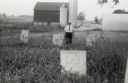
| Date: | 1958 |
|---|---|
| Description: | Local historian William F. Wolf visiting the Native American cemetery. In the background is a barn and a silo and other farm buildings. |
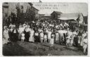
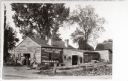
| Date: | 07 01 1917 |
|---|---|
| Description: | View of a large group of people gathered for a Homecoming celebration. A young woman in the foreground is identified as Daisy Helen Hicken. |
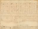
| Date: | |
|---|---|
| Description: | This map, which was likely drawn in the mid-19th century, shows land ownership on the Stockbridge Reservation on the shore of Lake Winnebago in what is now... |

| Date: | 1900 |
|---|---|
| Description: | This map shows landownership circa 1848 in the old Stockbridge Indian reservation on Lake Winnebago in Calumet County. It is oriented with north to the lef... |
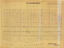
| Date: | 1955 |
|---|---|
| Description: | This map shows landownership in the old Stockbridge Indian reservation on Lake Winnebago in Calumet County. The lots are numbered and labeled by owner. A b... |

| Date: | 1836 |
|---|---|
| Description: | This negative photostat map shows the "oak tree, place of beginning" on the division line between Stockbridge and Brothertown Indians, and Governor Porter'... |

| Date: | 1974 |
|---|---|
| Description: | This map draws content from a map originally created by George Featherstongaugh in 1840. The map shows streets, land ownership, the Brotherton Indian reser... |
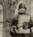
| Date: | 03 1934 |
|---|---|
| Description: | View of a woman holding a large bound volume and standing next to a tree. Caption reads: "An Indian woman of over 70 [Lura Fowler Kindness] who lives by he... |
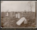
| Date: | 1906 |
|---|---|
| Description: | View of a cemetery with several tombstones, one of which appears broken and resting against its base. A building is in the background. Caption reads: "Th... |
If you didn't find the material you searched for, our Library Reference Staff can help.
Call our reference desk at 608-264-6535 or email us at: