Filter: Categories of Wisconsin Historical Images
Filter: Subject of Wisconsin State Capitol
Filter: Subject of land
Filter: Categories of Wisconsin Historical Images
Filter: Subject of Wisconsin State Capitol
Filter: Subject of land
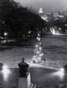
| Date: | 1960 |
|---|---|
| Description: | Elevated view looking east from Lincoln Terrace on Bascom Hill on the University of Wisconsin-Madison campus. The Lincoln Monument is in the foreground and... |

| Date: | 1952 |
|---|---|
| Description: | Aerial view of a North Central Airlines DC-3 airplane flying over the Madison isthmus. Clearly visible are the Wisconsin State Capitol, the 1 West Wilson S... |
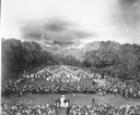
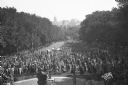
| Date: | 1916 |
|---|---|
| Description: | Maypole dancers at the University of Wisconsin-Madison on Bascom Hill (Main Hill). In the foreground is the Lincoln Monument. In the distance is the Wiscon... |

| Date: | 1908 |
|---|---|
| Description: | Colored map showing a panoramic view of Madison in great detail. The Wisconsin State Capitol is located at the center, with Lake Mendota in the background ... |
| Date: | 1945 |
|---|---|
| Description: | Elevated view of the Wisconsin State Capitol. The Belmont Hotel is behind the capitol on the left, and beyond is Lake Mendota. |

| Date: | 1908 |
|---|---|
| Description: | A panoramic aerial view of the Isthmus taken from a kite. Lake Mendota is to the right in the background with Picnic Point jutting into the lake. The photo... |
| Date: | 1930 |
|---|---|
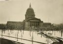
| Description: | Elevated view of the west wing of the Wisconsin State Capitol building. A view of the fourth capitol with snow flocked trees and snow-covered lawn and side... |
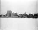
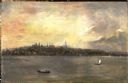
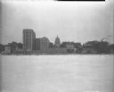
| Date: | 12 18 1955 |
|---|---|
| Description: | Downtown Madison lakeshore taken from Lake Monona in line with South Pinckney Street. Includes St. Raphael's steeple, 1 West Wilson Street state office bui... |

| Date: | 05 09 1908 |
|---|---|
| Description: | Kite aerial panoramic photograph of the central business district. In the distance is Lake Mendota. The fire damaged Wisconsin State Capitol is in the cent... |

| Date: | 1885 |
|---|---|
| Description: | Bird's-eye map of Madison, State Capital of Wisconsin, County Seat of Dane County, with inset of the Wisconsin State Capitol. |
| Date: | 05 20 1933 |
|---|---|
| Description: | Wisconsin State Capitol from University of Wisconsin-Madison Bascom Hall on Lincoln Terrace. |

| Date: | 10 09 1928 |
|---|---|
| Description: | View of the Wisconsin State Capitol from the center of East Washington Avenue, looking through two trees planted on a wide grassy median. |

| Date: | 06 03 1928 |
|---|---|
| Description: | The Wisconsin State Capitol, from the Lincoln Terrace on Bascom Hill. |
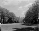
| Date: | 09 23 1927 |
|---|---|
| Description: | Elevated view of University of Wisconsin students on Bascom Hill, with the Wisconsin State Capitol in the distance. |
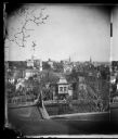
| Date: | 1873 |
|---|---|
| Description: | View, ca. 1873-1879, of Madison looking down Wisconsin Avenue toward the third Wisconsin Capitol, a view that suggests something of the ongoing importance ... |
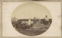
| Date: | |
|---|---|
| Description: | A view looking south down Wisconsin Avenue toward the Capitol Square where portions of the second and third Wisconsin State Capitols are visible. This pers... |

| Date: | 1855 |
|---|---|
| Description: | Part of George Harrison's "Map of the City of Madison," showing the development of the isthmus and the small size of the second Capitol (54' x 104') in com... |

| Date: | 1896 |
|---|---|
| Description: | A portion of John B. Heim's map of the Water Works System of Madison showing the size of the third Wisconsin Capitol (228' x 226') in comparison with the C... |
| Date: | 12 18 1955 |
|---|---|
| Description: | Downtown Madison shoreline taken from Lake Monona in line with Monona Avenue (Martin Luther King, Jr. Boulevard as of January 19, 1987). Includes Wisconsi... |
If you didn't find the material you searched for, our Library Reference Staff can help.
Call our reference desk at 608-264-6535 or email us at: