 Filter: Categories of Wisconsin Historical Images
Filter: Subject of Water
Filter: Subject of fruit
Filter: Categories of Wisconsin Historical Images
Filter: Subject of Water
Filter: Subject of fruit

| Date: | |
|---|---|
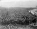
| Description: | Elevated view of a number of people unloading goods from boats arriving at a waterfront marketplace. Huts and various other buildings are visible on the hi... |

| Date: | 1951 |
|---|---|
| Description: | Overhead view of Doonga houseboats on the Jhelum River in Pakistan. |
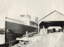
| Date: | 09 1925 |
|---|---|
| Description: | Large cargo ship operated by the Benton Transit Company. On the dock near an open shed are many bushels of fruit, including melons and tomatoes (according ... |
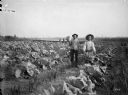
| Date: | 09 04 1895 |
|---|---|
| Description: | Men displaying produce, a large cabbage and a bushel of potatoes, while standing in the gardens of the Thayer farm. Cabbage, onion, currant, and raspberry ... |
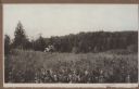
| Date: | 1925 |
|---|---|
| Description: | Two young men pick berries in a field on a hill near Juddville. Chambers Island is seen on the horizon of the Green Bay. |
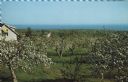
| Date: | |
|---|---|
| Description: | Elevated view of an orchard during apple blossom season, with Lake Superior in the distance. |

| Date: | |
|---|---|
| Description: | One-page menu for Chalet on the Lake, with a colored pen-and-ink still life of a vase of flowers and greenery on a table set with bottles of wine, wine gla... |

| Date: | |
|---|---|
| Description: | Front cover and partial menu listing with drinks overleaf. Front cover has a porthole view of pairs of men in three boats with mountains and palm trees in ... |
| Date: | 1902 |
|---|---|
| Description: | Elevated view of a banana plantation located along a river in Costa Rica. |
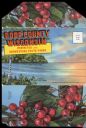
| Date: | 1920 |
|---|---|
| Description: | Envelope cover. Inside are eighteen color enhanced photographic scenes from Door County, Wisconsin, including a short description of Door County features t... |

| Date: | 1685 |
|---|---|
| Description: | A detailed map of the western hemisphere showing cities, settlements, Native American land, rivers, lakes, mountains, the Great Lakes, and California as an... |

| Date: | 1676 |
|---|---|
| Description: | Map of Virginia and Maryland, based on John Smith's 1612 map and Augustine Herman's 1673 seminal map. It shows borders, counties, Native American land, tri... |
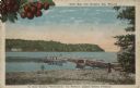
| Date: | |
|---|---|
| Description: | Color postcard view towards the shoreline, with a pier and three boats moored to it. On the far right is a portion of what may be a boathouse. There are bu... |

| Date: | |
|---|---|
| Description: | Color postcard across water towards a rock formation. Waves are breaking against the rocks below. In the upper-right corner of the postcard are cherries on... |
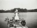
| Date: | 1911 |
|---|---|
| Description: | View from shoreline towards a girl, possibly Lillian Wheeler, standing on the pier at the Ark cottage on a sunny day. She is holding up some fruit and is w... |
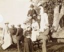
| Date: | 1902 |
|---|---|
| Description: | A group of young men and women are visiting McCauslin Brook. Standing on the tree trunk, W.A. Holt is holding a paper lantern. The woman, standing next to ... |
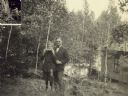
| Date: | 08 09 1923 |
|---|---|
| Description: | Freddy is biting into a slice of watermelon with Dr. McDaniels next to him. Archibald Lake, tall trees, and a cabin are in the background. Page title reads... |
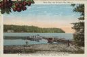
| Date: | 1915 |
|---|---|
| Description: | Caption reads: "Sister Bay, near Sturgeon Bay, Wis." and "In Door County 'Cherryland,' the Nation's Largest Cherry Producer." Sister Bay from a rocky beach... |
If you didn't find the material you searched for, our Library Reference Staff can help.
Call our reference desk at 608-264-6535 or email us at: