 Filter: Categories of Wisconsin Historical Images
Filter: Subject of Water
Filter: Subject of buffaloes
Filter: Categories of Wisconsin Historical Images
Filter: Subject of Water
Filter: Subject of buffaloes
| Date: | 1889 |
|---|---|
| Description: | Color lithograph illustration on the back cover of the McCormick Harvesting Machine Company catalog. Shows a buffalo gazing down upon men with harvesting m... |
| Date: | 1832 |
|---|---|
| Description: | Herds of bison and elk on the Upper Missouri River. |
| Date: | 1832 |
|---|---|
| Description: | Herd of Bison, on the Upper Missouri River. |

| Date: | 1906 |
|---|---|
| Description: | Cover of an advertising catalog for Buffalo Pitts threshers sold by International Harvester. The cover features an illustration of four buffalo standing ne... |
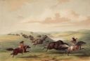
| Date: | 1844 |
|---|---|
| Description: | North American Indians on horseback during a buffalo hunt. "In [this plate], I have represented a party of Indians in chase of a herd, some of whom are pur... |

| Date: | |
|---|---|
| Description: | A Hawaiian farmer works in a field, ankle deep in water, with a water buffalo pulling a farming implement. |

| Date: | 1948 |
|---|---|
| Description: | This illustrated map shows major westward trails from 1785 to 1866: Old Oregon Trail and its deviations, Old Spanish Trail, Lewis and Clark route, Santa Fe... |

| Date: | 1783 |
|---|---|
| Description: | This map is hand-colored and shows the boundaries of British, Spanish, and the newly recognized American claims, as well as the fishing rights granted to F... |

| Date: | 1636 |
|---|---|
| Description: | Map of North America, divided into regions, and showing some rivers, lakes, settlements, cities, mountains, and Native American land. Of the Great Lakes on... |

| Date: | 1713 |
|---|---|
| Description: | Map showing the regions explored by Robert de La Salle between 1681 and 1686, as well as the route La Salle, and later Henri Joutel, took, moving north fro... |

| Date: | 1765 |
|---|---|
| Description: | Detailed map composed for the London Magazine of the Mississippi River Valley at the conclusion of the French and Indian War. The British colonies themselv... |

| Date: | 1783 |
|---|---|
| Description: | Map of the newly formed United States showing borders, regions, Native American land, cities, mountains, lakes, and rivers. It includes a small inset map o... |

| Date: | 1720 |
|---|---|
| Description: | Detailed, ornate, and comprehensive map of America from the east coast to present day Texas. Numerous features appear throughout the map, including Native ... |
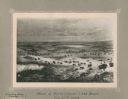
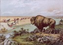
| Date: | 11 22 1919 |
|---|---|
| Description: | Print on card depicting a herd of Bison near Lake Jessie. Written under the title is the date: "July 10th, 1853" and "Shyenne River County." |

| Date: | |
|---|---|
| Description: | Moving provisions with wagons pulled by water buffalo. |
If you didn't find the material you searched for, our Library Reference Staff can help.
Call our reference desk at 608-264-6535 or email us at: