 Filter: Categories of Wisconsin Historical Images
Filter: Subject of War
Filter: Subject of rivers
Filter: Subject of intellectual life
Filter: Categories of Wisconsin Historical Images
Filter: Subject of War
Filter: Subject of rivers
Filter: Subject of intellectual life
| Date: | 1958 |
|---|---|
| Description: | 26th of July Movement soldiers rest by a river in Oriente Province while on patrol during the Cuban Revolution. They are sitting on a rocky bank of the riv... |

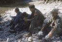
| Date: | 1962 |
|---|---|
| Description: | An American soldier inspects the papers of a Vietnamese man in the countryside along a river. Vietnamese soldiers and a boy are grouped around him. |

| Date: | 1758 |
|---|---|
| Description: | This detailed map of north eastern America shows the boundaries, cities, mountains, rivers, lakes, Native American land and towns, and roads from east of t... |

| Date: | 1758 |
|---|---|
| Description: | Map showing lakes, rivers, cities, Native American land, and the boundaries of French and English claims in America and Canada north of New York. A title c... |

| Date: | 1755 |
|---|---|
| Description: | Map of colonial America, showing the lands north of South Carolina and west of the Mississippi River. An inset map of the Carolinas and Georgia sits in the... |

| Date: | 1777 |
|---|---|
| Description: | Map of Colonial America east of Lake Michigan showing regions, cities, forts, Native American land, mountains, lakes, and rivers. Crossed swords and small ... |

| Date: | 1795 |
|---|---|
| Description: | Map of the United States east of the Mississippi River. It features roads, cities, towns, early settlements, Native American land, forts, mountains, rivers... |

| Date: | 1755 |
|---|---|
| Description: | Map of New England, with three inset maps of Fort Oswego, Fort du Quesne, and Fort Frederick. It shows colonies, a few cities, forts (marked as French or E... |

| Date: | 1781 |
|---|---|
| Description: | Map of the southern portion of the Chesapeake Bay and surrounding lands. It shows counties, a few cities and towns, forts, roads, islands, topographical fe... |
If you didn't find the material you searched for, our Library Reference Staff can help.
Call our reference desk at 608-264-6535 or email us at: