 Filter: Categories of Wisconsin Historical Images
Filter: Subject of War
Filter: Subject of mountains
Filter: Subject of cities and towns
Filter: Categories of Wisconsin Historical Images
Filter: Subject of War
Filter: Subject of mountains
Filter: Subject of cities and towns

| Date: | 05 1961 |
|---|---|
| Description: | Aerial view of the town of Luang Prabang, Laos. Trees are interspersed among houses and roads and green mountains encircle the town. The golden roof of Pho... |

| Date: | 1961 |
|---|---|
| Description: | Aerial view of a small settlement in the mountains, Luang Prabang vicinity, Laos. A narrow dirt road winds across the terrain and some buildings and an air... |

| Date: | 1961 |
|---|---|
| Description: | Keukacham Meo settlement, Laos with American special forces and Lao infantrymen. Two soldiers talk near a tent and another works atop a mud-spattered jeep. |

| Date: | 1961 |
|---|---|
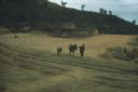
| Description: | A woman carrying a basket on her back leads a mule laden with bundles across an airstrip at Keukacham village, Laos. There are 55-gallon drums near a tent,... |
| Date: | 1961 |
|---|---|
| Description: | A woman leads a mule laden with bundles across the airstrip at the village of Keukacham, Laos. A young mule follows. In the background at the base of a hil... |

| Date: | 1961 |
|---|---|
| Description: | View of Keukacham village, Laos from behind a tank. A partially thatched building is in the foreground and other buildings on a dirt road are visible in th... |

| Date: | 1961 |
|---|---|
| Description: | Elevated view of Keukacham village, Laos. Three soldiers stand talking in the foreground by a large, open, white tent. In the background is a rubble pile, ... |

| Date: | 1961 |
|---|---|
| Description: | Aerial view of Keukacham village, Laos including landing strip with helicopter. The small settlement is clearly visible contrasted against the verdant gree... |

| Date: | 1962 |
|---|---|
| Description: | Silhouette of a machine gun in an Army helicopter and a scenic view of the mountain region in Vietnam below. Green mountains rise next to developed country... |

| Date: | 1758 |
|---|---|
| Description: | This detailed map of north eastern America shows the boundaries, cities, mountains, rivers, lakes, Native American land and towns, and roads from east of t... |

| Date: | 1755 |
|---|---|
| Description: | Map of colonial America, showing the lands north of South Carolina and west of the Mississippi River. An inset map of the Carolinas and Georgia sits in the... |

| Date: | 1777 |
|---|---|
| Description: | Map of Colonial America east of Lake Michigan showing regions, cities, forts, Native American land, mountains, lakes, and rivers. Crossed swords and small ... |

| Date: | 1795 |
|---|---|
| Description: | Map of the United States east of the Mississippi River. It features roads, cities, towns, early settlements, Native American land, forts, mountains, rivers... |

| Date: | 1780 |
|---|---|
| Description: | Detailed topographical and political map of the area from Lake Champlain to Albany and the Hudson River. Relief is shown through hachures. The map shows ci... |

| Date: | 10 1776 |
|---|---|
| Description: | Broadside map showing the British invasion of New York city in August and September of 1776. The map shows important cities, forts, roads, hills, mountains... |
If you didn't find the material you searched for, our Library Reference Staff can help.
Call our reference desk at 608-264-6535 or email us at: