 Filter: Categories of Wisconsin Historical Images
Filter: Subject of War
Filter: Subject of maps
Filter: Categories of Wisconsin Historical Images
Filter: Subject of War
Filter: Subject of maps
| Date: | |
|---|---|
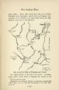
| Description: | Hand-drawn map of the location of the Fox Indian Wars. |

| Date: | 1942 |
|---|---|
| Description: | Photographic copy of a poster made by International Harvester's advertising department to solicit funds for the International Harvester Company's World War... |

| Date: | 1958 |
|---|---|
| Description: | Meeting of the 26th of July Movement in the woods of Oriente Province during the Cuban Revolution. Fidel Castro, Juan Almeida Bosque and Vilma Espin crouch... |

| Date: | 1958 |
|---|---|
| Description: | Meeting of the 26th of July Movement in the woods of Oriente Province during the Cuban Revolution. A number of participants, including Vilma Espin and Juan... |

| Date: | 1958 |
|---|---|
| Description: | Meeting of the 26th of July Movement in Oriente Province during the Cuban Revolution. A number of participants, including Vilma Espin, Raúl Castro and Juan... |
| Date: | 1958 |
|---|---|
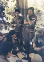
| Description: | Meeting of the 26th of July Movement in Oriente Province during the Cuban Revolution. Vilma Espin and Fidel Castro crouch over a map spread on the ground.... |

| Date: | 1958 |
|---|---|
| Description: | Meeting of the 26th of July Movement in Oriente Province during the Cuban Revolution. Vilma Espin stands in the middle with a gun, and Raúl Castro and Juan... |

| Date: | 1962 |
|---|---|
| Description: | Soldier at work at a desk in an Air Support Operations Center, Da Nang, Vietnam. There is a large map on the wall, military radios, a clock and a military ... |
| Date: | 1976 |
|---|---|
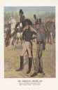
| Description: | "A general staff officer stands in the left foreground in the single-breasted blue coat with black herringbone false buttonholes on the chest and cuffs and... |
| Date: | 1991 |
|---|---|
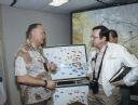
| Description: | Congressman David Obey was part of a delegation that visited the Middle East during the Persian Gulf War. This photograph was taken following a briefing by... |
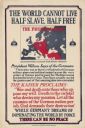
| Date: | 1918 |
|---|---|
| Description: | Propaganda poster encouraging American involvement in World War I by depicting the Prussian army as enslaving Europe. Includes a map of Europe with the lan... |

| Date: | 1758 |
|---|---|
| Description: | This detailed map of north eastern America shows the boundaries, cities, mountains, rivers, lakes, Native American land and towns, and roads from east of t... |

| Date: | 1758 |
|---|---|
| Description: | Map showing lakes, rivers, cities, Native American land, and the boundaries of French and English claims in America and Canada north of New York. A title c... |

| Date: | 1755 |
|---|---|
| Description: | Map of colonial America, showing the lands north of South Carolina and west of the Mississippi River. An inset map of the Carolinas and Georgia sits in the... |

| Date: | 1777 |
|---|---|
| Description: | Map of Colonial America east of Lake Michigan showing regions, cities, forts, Native American land, mountains, lakes, and rivers. Crossed swords and small ... |

| Date: | 1795 |
|---|---|
| Description: | Map of the United States east of the Mississippi River. It features roads, cities, towns, early settlements, Native American land, forts, mountains, rivers... |

| Date: | 1755 |
|---|---|
| Description: | Map of New England, with three inset maps of Fort Oswego, Fort du Quesne, and Fort Frederick. It shows colonies, a few cities, forts (marked as French or E... |
If you didn't find the material you searched for, our Library Reference Staff can help.
Call our reference desk at 608-264-6535 or email us at: