 Filter: Categories of Wisconsin Historical Images
Filter: Subject of War
Filter: Subject of botany
Filter: Categories of Wisconsin Historical Images
Filter: Subject of War
Filter: Subject of botany
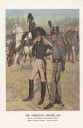
| Date: | 1976 |
|---|---|
| Description: | "A general staff officer stands in the left foreground in the single-breasted blue coat with black herringbone false buttonholes on the chest and cuffs and... |
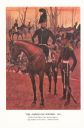
| Date: | 1976 |
|---|---|
| Description: | "The figure on foot in the right foreground shows a sergeant of light artillery in the all blue uniform trimmed with yellow prescribed in January 1812, whe... |
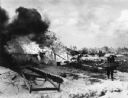
| Date: | 12 26 1967 |
|---|---|
| Description: | Typed note on the back: SGP...UNIPIX North of Hue, South Vietnam: A Vietnamese woman carries her possessions as her home burns behind her. The South Vietn... |
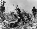
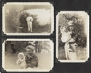
| Date: | |
|---|---|
| Description: | A woman is placing a baby in a basket held by a little boy. Behind her, a man lies prone holding another child, while two soldiers walk towards a house in ... |
| Date: | |
|---|---|
| Description: | The fife and drum are not so innocent the vulture's eye is on the dance |
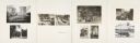
| Date: | |
|---|---|
| Description: | Page from Joy Camps photo album displaying three photographs. In one a man poses in a white military uniform holding his hat, with a lake and distant shore... |
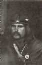
| Date: | |
|---|---|
| Description: | A candid portrait of a Vietnam veteran with a moustache, wearing a headband with a flower tucked in it, and a Vietnam Veterans Against the War button. He i... |

| Date: | 1758 |
|---|---|
| Description: | Map showing lakes, rivers, cities, Native American land, and the boundaries of French and English claims in America and Canada north of New York. A title c... |

| Date: | 1755 |
|---|---|
| Description: | Map of colonial America, showing the lands north of South Carolina and west of the Mississippi River. An inset map of the Carolinas and Georgia sits in the... |

| Date: | 1755 |
|---|---|
| Description: | Map of New England, with three inset maps of Fort Oswego, Fort du Quesne, and Fort Frederick. It shows colonies, a few cities, forts (marked as French or E... |

| Date: | 1985 |
|---|---|
| Description: | A man is standing and posing outdoors. He is wearing a small pin that reads "Stop the Bombing in El Salvador CISPES." Caption reads: "Martin Wolke, organiz... |
If you didn't find the material you searched for, our Library Reference Staff can help.
Call our reference desk at 608-264-6535 or email us at: