 Filter: Categories of Wisconsin Historical Images
Filter: Subject of Voyages and travels
Filter: Subject of land
Filter: Subject of transportation
Filter: Categories of Wisconsin Historical Images
Filter: Subject of Voyages and travels
Filter: Subject of land
Filter: Subject of transportation

| Date: | 1821 |
|---|---|
| Description: | Engraving depicting the Schoolcraft expedition crossing the Ontonagon River to investigate a copper boulder. |

| Date: | 1893 |
|---|---|
| Description: | Front and back covers of an advertising brochure for the New Empire line of mowers, reapers and grain binders manufactured by J.F. Seiberling & Company. Th... |

| Date: | 1632 |
|---|---|
| Description: | The Wisconsin portion of Champlain's 1632 map, augmented since the previous one, for navigation according to the true Meridien, by Sieur de Champlain. The ... |
| Date: | 03 30 1938 |
|---|---|
| Description: | Mrs. Attilio Gatti carried by four Congolese men during her husband's expedition to the African Congo. The expedition was sponsored by the International Ha... |
| Date: | 1938 |
|---|---|
| Description: | Two specially designed International trucks connected with an awning at an African camp site. The camp site was home to an Attilio Gatti expedition. The sp... |

| Date: | |
|---|---|
| Description: | A painting depicting Marquette and Joliet in a birch bark canoe with two other men during their excursion on the Mississippi River, which they discovered o... |

| Date: | 1919 |
|---|---|
| Description: | This map depicts the route of the 1842 overland trip by wagon made by the Reverend Alfred Brunson and some copper miners from Prairie du Chien to the mouth... |

| Date: | 1925 |
|---|---|
| Description: | De Prorok's car, Sandy and all members of the expedition: Pond, Tyrrell, De Prorok, Martini, Denny, Reygasse, Chauffeur Barth, Chapuis, Belaid, and in fron... |

| Date: | 1836 |
|---|---|
| Description: | This map depicts Wisconsin and Michigan territories in 1836. It includes the area from Michigan to the Missouri River and Lake Winnipeg, and it shows the e... |

| Date: | 02 1823 |
|---|---|
| Description: | A map featuring the North American expedition from Pittsburgh to the Rocky Mountains led by Edwin James. |

| Date: | 1936 |
|---|---|
| Description: | This manuscript map shows the route traveled by the Schoolcraft expedition in July 1831 between the Namekagon River and Lake Owen in the Town of Cable, Bay... |

| Date: | 1679 |
|---|---|
| Description: | Decorative and detailed map of the eastern half of North America. Regions, cities, colonies, Native America land, rivers, lakes and some nautical features ... |

| Date: | 1684 |
|---|---|
| Description: | Map of North America showing some colonies, cities, rivers, lakes, and Native American land. Ship routes spread across both oceans, including one decorated... |

| Date: | 1775 |
|---|---|
| Description: | This six sheet large format map is one of the most informative maps of its time. It shows cities, Native American land, lakes, rivers, mountains, topograph... |
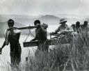
| Date: | 1909 |
|---|---|
| Description: | Two of The Gang carrying a canoe on a portage in the Presque Isle River. |

| Date: | 12 1927 |
|---|---|
| Description: | View towards a man standing behind a "Saraha" truck. Hills are in the background. |
| Date: | 12 1927 |
|---|---|
| Description: | Outdoor view of a man sitting on the side of a truck, wearing a hat and a cloth over his mouth. |
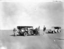
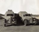
| Date: | 12 1927 |
|---|---|
| Description: | View across sand towards a group of men standing near two trucks in the Sahara Desert. |

| Date: | 1925 |
|---|---|
| Description: | Hand-colored lantern slide showing a group of men on an archaeological expedition in Algeria pushing one of the expedition vehicles nicknamed "Hot Dog" in ... |
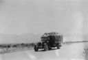
| Date: | 07 16 1928 |
|---|---|
| Description: | View of a truck on a road. Mountains are in the background. |
If you didn't find the material you searched for, our Library Reference Staff can help.
Call our reference desk at 608-264-6535 or email us at: