 Filter: Categories of Wisconsin Historical Images
Filter: Subject of Superior, Lake
Filter: Subject of ferries
Filter: Categories of Wisconsin Historical Images
Filter: Subject of Superior, Lake
Filter: Subject of ferries
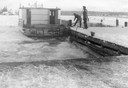
| Date: | 12 1948 |
|---|---|
| Description: | Two men docking a ferry boat at La Pointe in December. Ferry service closed two days after this photograph was taken. |
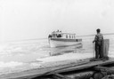
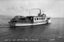
| Date: | 04 10 1948 |
|---|---|
| Description: | Man standing on dock watching the ferry "Gar-How" coming to dock on the first trip in spring. |
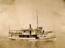
| Date: | 1895 |
|---|---|
| Description: | Captain F.A. Bishoff and engineer Dan Cook on board the ferry "Plowboy." |
| Date: | 05 16 1973 |
|---|---|
| Description: | View of the ferry "Gar-How" taken from on board the ferry "Island Queen" while both were docked at Madeline Island. The "Gar-How" was named after Howard Ru... |
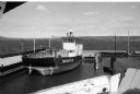
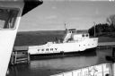
| Date: | 05 16 1973 |
|---|---|
| Description: | Steel-hulled ferry "Nichevo II" at the city dock in La Pointe. The "Nichevo II" began service in 1962. It was built by Fraser Shipyards of Superior for Har... |
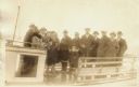
| Date: | 1920 |
|---|---|
| Description: | Group of people standing on board a passenger ferry bound for a New Year's trip to Ashland. |
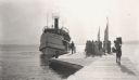
| Date: | 1910 |
|---|---|
| Description: | Ferry boat "Skater" and sailboat "Perhaps" near the Mission Dock. A group of people are waiting on the dock for the "Skater" to arrive. There is a boy carr... |
| Date: | 1938 |
|---|---|
| Description: | A car ferry transporting a car on Lake Superior between LaPointe, Madeline Island, and Bayfield. Two men are sitting on a bench near the car, and a shoreli... |

| Date: | 1939 |
|---|---|
| Description: | This nine-part map from the U.S. Bureau of Public Roads identifies federal and state highways in Wisconsin by pavement type. County, forest, park, and publ... |

| Date: | 1944 |
|---|---|
| Description: | This nine-part map from the U.S. Bureau of Public Roads identifies federal and state highways in Wisconsin by pavement type. County, forest, park, and publ... |

| Date: | 1950 |
|---|---|
| Description: | This road map shows federal, state and county roads in Wisconsin, northern Illinois, northeastern Iowa, eastern Minnesota, and the western portion of Michi... |

| Date: | |
|---|---|
| Description: | Color postcard of view across water towards the "Nichevo II" ferry for Bayfield-Madeline Island moving through the water and filled with tourists and their... |

| Date: | 1911 |
|---|---|
| Description: | This map of Duluth and Superior shows street car routes, railroads, ferries, some points of interest, and lighthouses. The bottom left of the map reads: "C... |

| Date: | 1923 |
|---|---|
| Description: | This map shows portions of Minnesota, Iowa, Wisconsin, Illinois, Indiana, Ohio, Michigan, New York, Vermont, Massachusetts, Connecticut, Ontario, and Quebe... |

| Date: | 1936 |
|---|---|
| Description: | This map shows road surfaces, construction, flying fields, seaplane landings, populations of cities and towns, and ferry routes of Wisconsin and some of th... |

| Date: | 1930 |
|---|---|
| Description: | This map shows the entire state plus portions of Illinois, Iowa, Minnesota, and Michigan outlined in blue. The map shows roads, state parks (black triangle... |

| Date: | 1928 |
|---|---|
| Description: | This map shows the entire state of Wisconsin as well as portions of Michigan, Minnesota, Iowa and Illinois. Lake Michigan, Lake Superior, Lake Winnebago a... |

| Date: | 1934 |
|---|---|
| Description: | This road map contains automobile routes for the state of Wisconsin as well as portions of Minnesota, Illinois, Iowa and Michigan. Lake Michigan, Lake Sup... |

| Date: | 1935 |
|---|---|
| Description: | This colored road map comes with a map legend and explanation, as well as an index of cities and towns (and their populations) in Wisconsin. Information ab... |

| Date: | 1936 |
|---|---|
| Description: | This colored road map shows automobile roads in Wisconsin as well as portions of Michigan, Iowa, Minnesota, and Illinois. U.S. numbered highways are shown ... |
If you didn't find the material you searched for, our Library Reference Staff can help.
Call our reference desk at 608-264-6535 or email us at: