 Filter: Categories of Wisconsin Historical Images
Filter: Subject of Slavery
Filter: Subject of arts
Filter: Categories of Wisconsin Historical Images
Filter: Subject of Slavery
Filter: Subject of arts
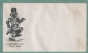
| Date: | 1860 |
|---|---|
| Description: | A grinning African American man wears a tattered version of Uncle Sam's costume as he dances and sings. The caption below reads, "I'm glad I'm not in... |
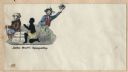
| Date: | 1860 |
|---|---|
| Description: | A slave is being whipped by a slave owner as he kneels and prays next to a bale of cotton labeled "COTTON" and "CSA." John Bull sits on the bale facing awa... |
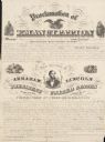
| Date: | |
|---|---|
| Description: | Text of the Emancipation Proclamation by Abraham Lincoln. Includes a portrait of Abraham Lincoln. |
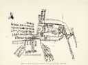
| Date: | |
|---|---|
| Description: | A hand-drawn map of a house labeled in both English and Chinese. Notes include escape routes. Two girls were kept here. |
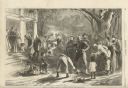
| Date: | 04 04 1863 |
|---|---|
| Description: | Illustration depicting a large group of people gathered in the yard of a house. Three woman stand on the porch steps, and men, women and children are gathe... |

| Date: | 1917 |
|---|---|
| Description: | Louisiana doctor Dudley Duprez, played by Frank Keenan, makes a fist and glares angrily in a scene still for "The Bride of Hate," a drama of miscegenation ... |

| Date: | 1783 |
|---|---|
| Description: | This map is hand-colored and shows the boundaries of British, Spanish, and the newly recognized American claims, as well as the fishing rights granted to F... |

| Date: | 1770 |
|---|---|
| Description: | The south west sheet of a four sheet map of Virginia, showing the counties, mountains, rivers, court houses, a few cities, and mills. A few Plantations ar... |

| Date: | 1780 |
|---|---|
| Description: | This map shows the townships, parishes, cities, towns, plantations, lakes, rivers, swamps, and roads near the coast of South Carolina and Georgia. Emphasis... |

| Date: | 1755 |
|---|---|
| Description: | Map of Virginia and parts of Maryland, North Carolina, and New Jersey. It shows borders, boundary lines, some Native American land, counties, cities, towns... |
If you didn't find the material you searched for, our Library Reference Staff can help.
Call our reference desk at 608-264-6535 or email us at: