 Filter: Categories of Wisconsin Historical Images
Filter: Subject of Ships
Filter: Subject of battles
Filter: Categories of Wisconsin Historical Images
Filter: Subject of Ships
Filter: Subject of battles
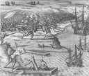
| Date: | 1655 |
|---|---|
| Description: | Scene from Christopher Columbus' fourth voyage, 1502-1504. |
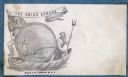
| Date: | 1860 |
|---|---|
| Description: | A Union sailor and King Neptune stand inside a sea shell that is floating on the ocean. Between them appears a decorative circle with the Union Armada in i... |
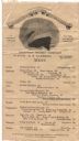
| Date: | 09 07 1913 |
|---|---|
| Description: | One-page menu printed on a wide silk ribbon to commemorate the victory of Commodore Oliver Hazard Perry at the Battle of Lake Erie during the War of 1812, ... |

| Date: | 1733 |
|---|---|
| Description: | This map of North America shows settlements, rivers, lakes, Native American land, trade winds, and numerous topographical features such as forests and moun... |

| Date: | 1770 |
|---|---|
| Description: | Map of North America from the Great Lakes to the northern portion of South America. It shows cities, Native American land, mountains, swamps, lakes, rivers... |

| Date: | 1767 |
|---|---|
| Description: | Map of the north east coast of America, showing colonial borders, cities, Native American land, lakes, rivers, and a few hills and mountains. Illustrated t... |

| Date: | 10 1776 |
|---|---|
| Description: | Broadside map showing the British invasion of New York city in August and September of 1776. The map shows important cities, forts, roads, hills, mountains... |

| Date: | 03 1777 |
|---|---|
| Description: | Map showing the British and Hessian attack on Fort Washington in November of 1776. The movements and fortifications of the British and Hessian troops appea... |
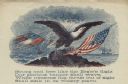
| Date: | |
|---|---|
| Description: | Letterhead of an eagle sitting on a rock. The American flag is on the right, and the first Confederate flag, which is tattered and being struck by lightnin... |
If you didn't find the material you searched for, our Library Reference Staff can help.
Call our reference desk at 608-264-6535 or email us at: