 Filter: Categories of Wisconsin Historical Images
Filter: Subject of Railroads
Filter: Year of 1800-1899
Filter: Year of 1850-1859
Filter: Categories of Wisconsin Historical Images
Filter: Subject of Railroads
Filter: Year of 1800-1899
Filter: Year of 1850-1859

| Date: | 1856 |
|---|---|
| Description: | This map show the surveyed southern part of state and includes "profile of the Milwaukee and Mississippi Rail Road." Counties are shown in pink, green, blu... |

| Date: | 1856 |
|---|---|
| Description: | View looking west from Lake Michigan with several steam ships and sailing vessels in harbor. There is a lighthouse to left of center, along shoreline. |

| Date: | 07 17 1857 |
|---|---|
| Description: | A stock certificate of the Watertown and Madison Railroad Company, one share #85, issued to Darwin Clark for the sum of $50.00. This was signed by the rail... |

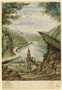
| Date: | 1857 |
|---|---|
| Description: | From Judge Smith Addition, 5th Ward, looking north, toward the city. Drawing is an elevated view of field and plank fence in foreground, road to the left a... |

| Date: | 1855 |
|---|---|
| Description: | Part of George Harrison's "Map of the City of Madison," showing the development of the isthmus and the small size of the second Capitol (54' x 104') in com... |
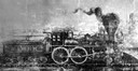
| Date: | 1850 |
|---|---|
| Description: | Drawing of an early locomotive that the Milwaukee and Mississippi Railroad rebuilt to run on the M.& M. R.R. line (which was later absorbed into the Chicag... |
| Date: | 1857 |
|---|---|
| Description: | Business with Frank Leslie's Illustrated Newspaper took Hölzlhuber to New York, and from there he also visited Philadelphia, Baltimore, and Washingt... |
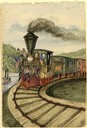
| Date: | 1857 |
|---|---|
| Description: | At the opening of the railway between Grandhaven and Grand Rapids, Michigan on July 26, 1857, the locomotive Grand Rapids was manned by the railroad... |
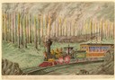
| Date: | 1859 |
|---|---|
| Description: | The maple and hickory forests in the old northwest were often plagued with fires during the summer months. Hölzlhuber, on a return journey from Niagara Fal... |

| Date: | 1858 |
|---|---|
| Description: | Hölzlhuber traveled on American railways frequently and marveled that they wouldn't have been accepted as usable in Europe. This sketch of the tunnel on th... |

| Date: | 1856 |
|---|---|
| Description: | Wisconsin map illustrating the Mineral Point Railroad and its connections. |
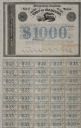
| Date: | 1857 |
|---|---|
| Description: | One thousand dollar bond and unclipped coupons issued by the city of Madison in 1857. The bond was illustrated with a railroad train, perhaps to suggest th... |

| Date: | 1855 |
|---|---|
| Description: | Map of the city of Madison, Dane County, published by George Harrison, surveyed and drawn by P. McCabe, and engraved by J.H. Colton & Co., New York. In add... |
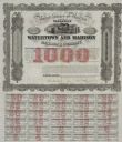
| Date: | 1857 |
|---|---|
| Description: | One thousand dollar bond and coupons issued by the Watertown and Madison Railroad Company in 1857. Jairus Fairchild, president, and T.L. Lawrence have sig... |
| Date: | 1857 |
|---|---|
| Description: | Draft newspaper editorial, "Our Railroad Prospects," written by former governor Leonard J. Farwell. |

| Date: | 1859 |
|---|---|
| Description: | This 1859 railroad map shows counties, cities, rivers and lakes in the entire state of Wisconsin. It includes an inset depicting the railroads in Milwaukee... |

| Date: | 1850 |
|---|---|
| Description: | [... through northern United States from New York to Minnesota]. Lithography by T. Sinclair. From Perrault papers, Lucien S. Hanks, donor. |

| Date: | 1853 |
|---|---|
| Description: | Shows railroads, planned and in place. |

| Date: | 1852 |
|---|---|
| Description: | Map reads: "The State of Wisconsin- compiled from the latest authorities". In addition, there is a scale which is six miles for every inch, and a profile o... |
If you didn't find the material you searched for, our Library Reference Staff can help.
Call our reference desk at 608-264-6535 or email us at:
