 Filter: Categories of Wisconsin Historical Images
Filter: Subject of Prairies
Filter: Categories of Wisconsin Historical Images
Filter: Subject of Prairies

| Date: | |
|---|---|
| Description: | A woman is standing and bending over in a field of dandelions gone to seed under a large tree. The sun is setting in the background. |

| Date: | 1718 |
|---|---|
| Description: | First edition of L'Isle's landmark map of North America. It covers America from the Rio Grande to the Atlantic Ocean, showing boundaries, the colonies, cit... |

| Date: | 1720 |
|---|---|
| Description: | Map of North America from from the Rio Grande to the Atlantic Ocean, showing boundaries, the colonies, cities, settlements, mines, forts, Native American l... |

| Date: | 1720 |
|---|---|
| Description: | Detailed, ornate, and comprehensive map of America from the east coast to present day Texas. Numerous features appear throughout the map, including Native ... |

| Date: | 1782 |
|---|---|
| Description: | Map of America covering the Rio Grande to the Atlantic Ocean, showing boundaries, the colonies, cities, settlements, Native American lands and villages, m... |
| Date: | 11 22 1919 |
|---|---|
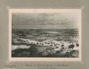
| Description: | Print on card depicting a herd of Bison near Lake Jessie. Written under the title is the date: "July 10th, 1853" and "Shyenne River County." |

| Date: | 10 1776 |
|---|---|
| Description: | Broadside map showing the British invasion of New York city in August and September of 1776. The map shows important cities, forts, roads, hills, mountains... |

| Date: | 1755 |
|---|---|
| Description: | Map of Virginia and parts of Maryland, North Carolina, and New Jersey. It shows borders, boundary lines, some Native American land, counties, cities, towns... |

| Date: | 1795 |
|---|---|
| Description: | Detailed map of Kentucky showing counties, cities, towns, Native American towns, forts, salt licks, roads, prairies, mountains, lakes, and rivers. Numerous... |
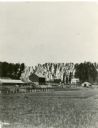
| Date: | 1886 |
|---|---|
| Description: | View across field towards a farm, with farmhouse, barn, outbuildings, and fences. The photograph appeared in Joseph Schafer's 1932 book The Wisconsin Le... |
| Date: | 06 30 1955 |
|---|---|
| Description: | From caption: "Prairie two miles north of Montfort Wis on the Iowa-Grant County line trunk highway I view to the east from the road. Photo by Robert Hall 1... |

| Date: | 1935 |
|---|---|
| Description: | A row of trucks are parked in a lot with trees in the background. The caption identifies the trucks as belonging to CCC 2670, the Madison-based 2670th Comp... |
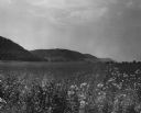
| Date: | 03 1953 |
|---|---|
| Description: | View across a prairie toward wooded hills. Caption reads: "Wisconsin River Valley. Bluffs as seen from Highway 80 west of Avoca, Wis." |

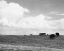
| Date: | 06 1952 |
|---|---|
| Description: | View across a prairie. Groves of trees, a herd of cattle, and a lake are in the distance. |

| Date: | 06 1950 |
|---|---|
| Description: | View across a gently sloping prairie field. Trees are in the distance, and power lines and a road are on the left. The Highway Commission descriptive remar... |

| Date: | 1950 |
|---|---|
| Description: | Castle Rock, surrounded by trees and a meadow. The geological feature is near Volk Field Air National Guard Base. |
If you didn't find the material you searched for, our Library Reference Staff can help.
Call our reference desk at 608-264-6535 or email us at:
