 Filter: Categories of Wisconsin Historical Images
Filter: Subject of Parks
Filter: Year of 1800-1899
Filter: Categories of Wisconsin Historical Images
Filter: Subject of Parks
Filter: Year of 1800-1899

| Date: | 1899 |
|---|---|
| Description: | A plat map showing Lake Monona, the isthmus in Madison, and the towns of Burke and Blooming Grove. |
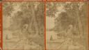
| Date: | 1890 |
|---|---|
| Description: | Stereograph view along shoreline of Geneva Lake at Porter's Park. A man sits in a canoe at the rocky shoreline while a woman sits and reads on a rustic ben... |
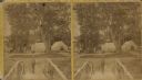
| Date: | 1890 |
|---|---|
| Description: | Stereograph view from footbridge with rustic railings of a small boy wearing a large hat standing at the end of the footbridge. A group of adults and anoth... |

| Date: | 1894 |
|---|---|
| Description: | This map shows sewers, intercepting sewers, manholes, block numbers, streets, railroads, parks, cemeteries, and Lake Michigan. The right margin reads: "Tot... |

| Date: | 1896 |
|---|---|
| Description: | This map shows streets, wards, railroads, parks, cemeteries, and Lake Michigan. Also included are explanations and an index of points of interest. |

| Date: | 1897 |
|---|---|
| Description: | Two maps that show cemeteries, schools, engine houses, railroads, street railways, wards, roads, parks, block numbers, and Lake Michigan. One map has wards... |

| Date: | 1879 |
|---|---|
| Description: | This map shows asylums, cemeteries, hospitals, parks, streets, and wards. Relief is shown by contours. Also included are manuscript annotations in pencil. ... |

| Date: | 1890 |
|---|---|
| Description: | This map shows city wards, block numbers, parks, cemeteries, roads, railroads, and selected buildings. The map includes indexes to streets, public building... |

| Date: | 1873 |
|---|---|
| Description: | Elevated view from Capitol Park of Madison City Hall with clock tower, 2 West Mifflin Street. Lake Mendota is in the far background. |

| Date: | 1898 |
|---|---|
| Description: | View across street towards the buildings on South Pinckney Street. The fence surrounding Capitol Park is on the left. The businesses have signs in their wi... |

| Date: | 1872 |
|---|---|
| Description: | This map shows wards, roads, railroads, lot and block numbers, subdivisions, parks, some landownership, and a race course. Manuscript annotations in red in... |

| Date: | 1880 |
|---|---|
| Description: | This map shows wards, roads, railroads, lot and block numbers, subdivisions, parks, and some landownership. A handwritten annotation in red reads: "Note: S... |

| Date: | 1890 |
|---|---|
| Description: | View from pier of groups of people walking along a Lake Monona dock and on the walkway to the shore. On the right is an excursion boat with a United States... |

| Date: | 1899 |
|---|---|
| Description: | A map of the east part of the city of Madison, including a portion of the isthmus. |

| Date: | 1857 |
|---|---|
| Description: | Elevated view from the Wisconsin State Capitol up State Street to Bascom Hall. There is a fence around the capitol grounds, and pedestrians are walking on ... |

| Date: | 1856 |
|---|---|
| Description: | This map shows the city as planned by the General Colonization Society, including streets, land parcels, two subdivisions of out-lots with graveyard, schoo... |

| Date: | 1892 |
|---|---|
| Description: | This map shows pipes of various sizes, hydrants with hydrant pressure, valves, wells, and projected lines. Includes labels for roadways, blocks, wards, par... |

| Date: | 1889 |
|---|---|
| Description: | This map lists township and section numbers outside municipality, housing additions and subdivisions and plat owners outside municipality, the Black River,... |
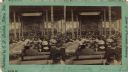
| Date: | 1890 |
|---|---|
| Description: | Stereograph of the interior of the Tabernacle during the Monona Lake Assembly. The assembly, Madison's annual Chautauqua, was held on the site of the prese... |

| Date: | 1897 |
|---|---|
| Description: | Five men are sitting in a forest clearing and playing brass instruments. Winnequah Point is on the shore of Lake Monona in what is now the City of Monona.... |
If you didn't find the material you searched for, our Library Reference Staff can help.
Call our reference desk at 608-264-6535 or email us at: