 Filter: Categories of Wisconsin Historical Images
Filter: Subject of Ocean
Filter: Subject of political science
Filter: Categories of Wisconsin Historical Images
Filter: Subject of Ocean
Filter: Subject of political science
| Date: | 1917 |
|---|---|
| Description: | Advertisement featuring a painting by artist Henry Mosler, dated 1915, titled "The Stars and Stripes Forever." In the painting a young man dressed in cut-o... |

| Date: | 1946 |
|---|---|
| Description: | This map shows scenes from America's history with names of historical events superimposed on a map of the United States. |

| Date: | 1715 |
|---|---|
| Description: | A map of the countries and islands surrounding the Gulf of Mexico. The hand-colored borders separate the territories of England, France, Spain, and Holland... |

| Date: | 1739 |
|---|---|
| Description: | This map shows the territorial claims of the western hemisphere by the European powers, as well as the names of major cities, geographical features, and pa... |

| Date: | 1746 |
|---|---|
| Description: | A map of the western hemisphere, including parts of western Europe and Africa, showing the division of the Americas by the European powers. Weapons and fol... |

| Date: | 1720 |
|---|---|
| Description: | One of Herman Moll's most famous maps, often referred to as The Beaver Map for its elaborate engraved inset depicting and describing beavers building a dam... |

| Date: | 1715 |
|---|---|
| Description: | One of Herman Moll's most famous maps, often referred to as The Codfish Map, it shows rivers and portages, cities, Indian villages, wind directions, routes... |

| Date: | 1720 |
|---|---|
| Description: | This map of North America shows cities, rivers, lakes, and a few topographical features, complete with numerous descriptive blocks of text about expedition... |

| Date: | 1746 |
|---|---|
| Description: | Map of North America from the southern portion of James Bay to Florida. It shows the colonies, cities, Native American land, and topological and geographic... |

| Date: | 1733 |
|---|---|
| Description: | This map of North America shows settlements, rivers, lakes, Native American land, trade winds, and numerous topographical features such as forests and moun... |

| Date: | 1770 |
|---|---|
| Description: | Map of North America from the Great Lakes to the northern portion of South America. It shows cities, Native American land, mountains, swamps, lakes, rivers... |

| Date: | |
|---|---|
| Description: | Two portraits of President George H.W. Bush. One caption on the reverse reads:"President Bush presides at a meeting of his Cabinet in the White House." The... |
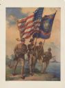
| Date: | 1917 |
|---|---|
| Description: | Poster featuring an illustration of four Marine corpsmen on a beach, with one Marine holding an American flag and another Marine a Marines flag. The other ... |
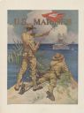
| Date: | 1917 |
|---|---|
| Description: | Poster featuring an illustration of two marine corpsmen on a shoreline. One Marine is standing and signaling with a signal flag to two battleships just off... |

| Date: | 1918 |
|---|---|
| Description: | Poster featuring an illustration of a submarine emerging from the ocean. About seven men are rising out of hatches on the conning tower and deck and waving... |
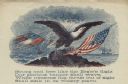
| Date: | |
|---|---|
| Description: | Letterhead of an eagle sitting on a rock. The American flag is on the right, and the first Confederate flag, which is tattered and being struck by lightnin... |
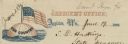
| Date: | 06 19 1862 |
|---|---|
| Description: | Letterhead of a globe floating in the ocean. The text: "Our Country" is printed onto the globe. The American flag is flying from the top of the globe. Text... |

| Date: | 1918 |
|---|---|
| Description: | Poster with an illustration of Uncle Sam arm-in-arm with Britannia. Uncle Sam has a sword, and Britannia holds a shield with the Union Jack and a triton. A... |

| Date: | 1853 |
|---|---|
| Description: | A map of Wellfleet Harbor on Cape Cod Bay. |
If you didn't find the material you searched for, our Library Reference Staff can help.
Call our reference desk at 608-264-6535 or email us at: