 Filter: Categories of Wisconsin Historical Images
Filter: Subject of Ocean
Filter: Subject of men
Filter: Categories of Wisconsin Historical Images
Filter: Subject of Ocean
Filter: Subject of men

| Date: | 1968 |
|---|---|
| Description: | Three-quarter view from front of passenger side of red International Scout with white Traveltop. Two people are in the front seat. The sides of the Travelt... |

| Date: | 1966 |
|---|---|
| Description: | Czechoslovakian film poster for the Soviet film "Sled v okeane." Image of divers in the blue ocean, with one having a photographic image for a face. A cros... |

| Date: | 1891 |
|---|---|
| Description: | Frederick Layton standing on deck smoking a cigar while at sea in a Kodak #2 camera portrait by T.W. Ingersoll from St. Paul, Minnesota. The photographer's... |

| Date: | |
|---|---|
| Description: | Frederick Layton is posing with Grace Hayman Fowle, his niece, and Grace's mother (the former Grace Dawson) near the rails on the deck of a ship. Behind th... |
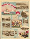
| Date: | 11 23 1930 |
|---|---|
| Description: | Full page illustrated article in the Milwaukee Journal titled "The World Voyagers go Round The Globe by Radio and Roto." Included are photographs an... |

| Date: | 1735 |
|---|---|
| Description: | A map of the western hemisphere, including parts of western Europe and Africa. Portraits of explorers, such as Jacques Marquette, Louis Joliet, and Robert ... |

| Date: | 1703 |
|---|---|
| Description: | Map of the Golf of Mexico and surrounding countries from the Great Lakes down to the northern most parts of South America. L'Isle labels cities, towns, and... |

| Date: | 1715 |
|---|---|
| Description: | One of Herman Moll's most famous maps, often referred to as The Codfish Map, it shows rivers and portages, cities, Indian villages, wind directions, routes... |

| Date: | 1780 |
|---|---|
| Description: | This map shows the northern Pacific Ocean with North America and Asia, with cities and geographical features labeled, as well Russian, French and Spanish r... |

| Date: | 1746 |
|---|---|
| Description: | This world map from the German mathematician, historian, and geographer Johann Matthias Hase shows the major cities, islands, and the major political divis... |

| Date: | 1627 |
|---|---|
| Description: | Map of North and South America showing settlements, rivers, lakes, mountains, islands and regions of the western hemisphere. It includes an inset map of Gr... |

| Date: | 1630 |
|---|---|
| Description: | One of the few maps by Dutch cartographer Willem Blaeu depicting the Americas, this map shows regions, settlements, islands, mountains, forests, rivers, an... |

| Date: | 1690 |
|---|---|
| Description: | A mysterious mixture of mythology, ancient geography, and late 17th century knowledge of the American coastline. This map shows North and South America, bu... |

| Date: | 1676 |
|---|---|
| Description: | Detailed map of North and South America. Cities, towns, forests, and mountains are shown pictorially. Duval labels regions, islands, cities, lakes, and Nat... |

| Date: | 1746 |
|---|---|
| Description: | Detailed map of the western hemisphere and part of Africa and Europe. Islands, cities, settlements, rivers, lakes, countries, and regions are marked. Mount... |

| Date: | 1759 |
|---|---|
| Description: | Map of North and South America showing regions, colonies, cities and settlements, rivers, lakes, and Native American land. Near the bottom left an inset ma... |

| Date: | 1636 |
|---|---|
| Description: | Map of North America, divided into regions, and showing some rivers, lakes, settlements, cities, mountains, and Native American land. Of the Great Lakes on... |

| Date: | 1684 |
|---|---|
| Description: | Map of North America showing some colonies, cities, rivers, lakes, and Native American land. Ship routes spread across both oceans, including one decorated... |

| Date: | 1719 |
|---|---|
| Description: | This extremely detailed and ornate map shows the cities, Native American land, mountains, lakes, rivers, and European claims of North America. An inset map... |

| Date: | 1760 |
|---|---|
| Description: | Map of North America based upon the cartographic work of de L'Isle. It shows cities, regions, lakes, rivers, Native American land, mountains, islands, and ... |
If you didn't find the material you searched for, our Library Reference Staff can help.
Call our reference desk at 608-264-6535 or email us at: