 Filter: Categories of Wisconsin Historical Images
Filter: Subject of Ocean
Filter: Subject of men
Filter: Subject of battles
Filter: Categories of Wisconsin Historical Images
Filter: Subject of Ocean
Filter: Subject of men
Filter: Subject of battles
| Date: | 12 07 1941 |
|---|---|
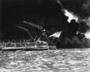
| Description: | Sailors clear the stern of the battleship USS West Virginia in berth F-6 at Pearl Harbor, most likely after it was hit by at least a few of the 7 to... |
| Date: | 12 07 1941 |
|---|---|
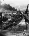
| Description: | The remains of the USS Cassin and the USS Downes floating in front of the USS Pennsylvania in dock at Pearl Harbor. On the left is th... |
| Date: | 12 07 1941 |
|---|---|
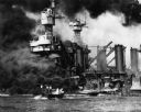
| Description: | Sailors in a motor launch attempt a rescue of survivors from the water alongside the sunken battleship USS West Virginia during or shortly after the... |
| Date: | 02 19 1945 |
|---|---|
| Description: | Marines on the beach and military boats, including an LSM 242, in the water at Iwo Jima. |
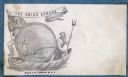
| Date: | 1860 |
|---|---|
| Description: | A Union sailor and King Neptune stand inside a sea shell that is floating on the ocean. Between them appears a decorative circle with the Union Armada in i... |
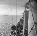
| Date: | 12 26 1943 |
|---|---|
| Description: | Elevated view from aboard ship looking down on a soldier in a turret operating a range finder. These warships were participating in the heavy bombardment o... |
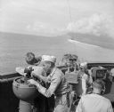
| Date: | 12 26 1943 |
|---|---|
| Description: | Navigation instruments on an American cruiser were checked by Lieutenant Commander Leonard Meyer of Appleton. Three other crew members are nearby. The crui... |
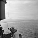
| Date: | 12 26 1943 |
|---|---|
| Description: | Elevated view looking down towards deck of an American cruiser leaving the base heading for the bombardment of Cape Gloucester, New Britain, New Guinea (pr... |
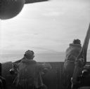
| Date: | 12 26 1943 |
|---|---|
| Description: | Seaman 2nd Class Jerry Burg (left) of Milwaukee, Wisconsin, and Seaman 2nd Class Harold Dawson of Toledo, Ohio, man the plane spotting station on an Americ... |
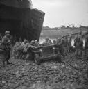
| Date: | 01 02 1944 |
|---|---|
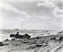
| Description: | Soldiers push a jeep that is stuck on the rocky beach at the Saidor landing. The open front of the LST (Landing Ship, Tank) is on the left. Another LST can... |

| Date: | 1740 |
|---|---|
| Description: | Engraved and hand-colored map of the Iberian peninsula as a theater of war during the War of the Spanish Succession (1701-1714). The map is dedicated to Ki... |

| Date: | 1733 |
|---|---|
| Description: | This map of North America shows settlements, rivers, lakes, Native American land, trade winds, and numerous topographical features such as forests and moun... |

| Date: | 1770 |
|---|---|
| Description: | Map of North America from the Great Lakes to the northern portion of South America. It shows cities, Native American land, mountains, swamps, lakes, rivers... |
If you didn't find the material you searched for, our Library Reference Staff can help.
Call our reference desk at 608-264-6535 or email us at: