 Filter: Categories of Wisconsin Historical Images
Filter: Subject of Ocean
Filter: Subject of men
Filter: Reproduction Rights of For Sale
Filter: Categories of Wisconsin Historical Images
Filter: Subject of Ocean
Filter: Subject of men
Filter: Reproduction Rights of For Sale

| Date: | 1690 |
|---|---|
| Description: | A mysterious mixture of mythology, ancient geography, and late 17th century knowledge of the American coastline. This map shows North and South America, bu... |

| Date: | 1676 |
|---|---|
| Description: | Detailed map of North and South America. Cities, towns, forests, and mountains are shown pictorially. Duval labels regions, islands, cities, lakes, and Nat... |

| Date: | 1746 |
|---|---|
| Description: | Detailed map of the western hemisphere and part of Africa and Europe. Islands, cities, settlements, rivers, lakes, countries, and regions are marked. Mount... |

| Date: | 1759 |
|---|---|
| Description: | Map of North and South America showing regions, colonies, cities and settlements, rivers, lakes, and Native American land. Near the bottom left an inset ma... |

| Date: | 1636 |
|---|---|
| Description: | Map of North America, divided into regions, and showing some rivers, lakes, settlements, cities, mountains, and Native American land. Of the Great Lakes on... |

| Date: | 1684 |
|---|---|
| Description: | Map of North America showing some colonies, cities, rivers, lakes, and Native American land. Ship routes spread across both oceans, including one decorated... |

| Date: | 1719 |
|---|---|
| Description: | This extremely detailed and ornate map shows the cities, Native American land, mountains, lakes, rivers, and European claims of North America. An inset map... |

| Date: | 1760 |
|---|---|
| Description: | Map of North America based upon the cartographic work of de L'Isle. It shows cities, regions, lakes, rivers, Native American land, mountains, islands, and ... |

| Date: | 1733 |
|---|---|
| Description: | This map of North America shows settlements, rivers, lakes, Native American land, trade winds, and numerous topographical features such as forests and moun... |

| Date: | 1770 |
|---|---|
| Description: | Map of North America from the Great Lakes to the northern portion of South America. It shows cities, Native American land, mountains, swamps, lakes, rivers... |

| Date: | |
|---|---|
| Description: | Two portraits of President George H.W. Bush. One caption on the reverse reads:"President Bush presides at a meeting of his Cabinet in the White House." The... |
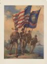
| Date: | 1917 |
|---|---|
| Description: | Poster featuring an illustration of four Marine corpsmen on a beach, with one Marine holding an American flag and another Marine a Marines flag. The other ... |
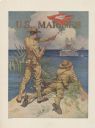
| Date: | 1917 |
|---|---|
| Description: | Poster featuring an illustration of two marine corpsmen on a shoreline. One Marine is standing and signaling with a signal flag to two battleships just off... |

| Date: | 1917 |
|---|---|
| Description: | Poster featuring an illustration of four Marine corpsmen running across a grassy beach. Two battleships are just off the shore in the background. Poster te... |

| Date: | 1918 |
|---|---|
| Description: | Poster featuring an illustration of a submarine emerging from the ocean. About seven men are rising out of hatches on the conning tower and deck and waving... |
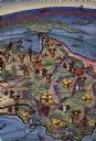
| Date: | 1938 |
|---|---|
| Description: | Back cover of "At Home Abroad" brochure featuring the continent of Australia. |
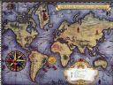
| Date: | 1938 |
|---|---|
| Description: | Inside spread of "At Home Abroad" brochure. The title reads: "A World-wide Sales and Service Organization." Features a map of the continents of the world. ... |

| Date: | 1917 |
|---|---|
| Description: | Poster with an illustration depicting an elevated view of a downed plane tail up and floating in the sea with survivors standing on top of it. A seaplane i... |
| Date: | 1901 |
|---|---|
| Description: | Stereograph of two sailors standing in a small boat as it is hoisted aboard the Battleship "Wisconsin." More sailors are in the lower right corner. Caption... |

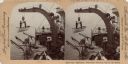
| Date: | 03 1913 |
|---|---|
| Description: | View across water towards a two-masted sailboat and a launch plying the waters of Havana Bay. Other boats are tied to the wharf in the background, with bui... |
If you didn't find the material you searched for, our Library Reference Staff can help.
Call our reference desk at 608-264-6535 or email us at: