 Filter: Categories of Wisconsin Historical Images
Filter: Subject of Ocean
Filter: Subject of cities and towns
Filter: Categories of Wisconsin Historical Images
Filter: Subject of Ocean
Filter: Subject of cities and towns

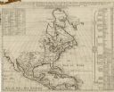
| Date: | 1733 |
|---|---|
| Description: | This map of North America shows settlements, rivers, lakes, Native American land, trade winds, and numerous topographical features such as forests and moun... |

| Date: | 1775 |
|---|---|
| Description: | This six sheet large format map is one of the most informative maps of its time. It shows cities, Native American land, lakes, rivers, mountains, topograph... |
| Date: | 1739 |
|---|---|
| Description: | Map of North America using sinusoidal projection to represent the curvature of the earth. It shows settlements and cities, Native American land, lakes, riv... |

| Date: | 1777 |
|---|---|
| Description: | This important map highlights the frantic desire and search for the north west passage. It shows a few settlements and mountains in Russia, north west Amer... |

| Date: | 1766 |
|---|---|
| Description: | Map representing the northern Pacific Ocean along with north eastern Asia and western North America. The interior of Asia contains very detailed engravings... |

| Date: | 1770 |
|---|---|
| Description: | Map of North America from the Great Lakes to the northern portion of South America. It shows cities, Native American land, mountains, swamps, lakes, rivers... |

| Date: | 1762 |
|---|---|
| Description: | Map including the land and islands surrounding the Gulf of Mexico. The regions and islands are labeled, as are a few rivers and cities. This map was engrav... |

| Date: | 1675 |
|---|---|
| Description: | Map of the southeast coast of North America from Jamestown to modern Georgia. It shows European settlements, Native American land and villages, coastal fea... |

| Date: | 1781 |
|---|---|
| Description: | Map of the Southeastern part of the British Colonies in North America, Gulf Coast and Caribbean. It illustrates the of the Spanish and English fleets, part... |

| Date: | 1917 |
|---|---|
| Description: | Poster with an illustration of a bird's-eye view of a large bald eagle flying over a convoy of ships, which are headed towards a fire or explosion over the... |

| Date: | 1917 |
|---|---|
| Description: | Poster featuring an illustration of four Marine corpsmen on a beach, with one Marine holding an American flag and another Marine a Marines flag. The other ... |

| Date: | 1918 |
|---|---|
| Description: | Poster depicting enemy aircraft bombing New York, which is in flames. In the foreground, the Statue of Liberty has been attacked and its head has been seve... |

| Date: | 1938 |
|---|---|
| Description: | Back cover of "At Home Abroad" brochure featuring the continent of Australia. |

| Date: | 1853 |
|---|---|
| Description: | A map of Wellfleet Harbor on Cape Cod Bay. |

| Date: | 03 1913 |
|---|---|
| Description: | View across water towards a two-masted sailboat and a launch plying the waters of Havana Bay. Other boats are tied to the wharf in the background, with bui... |
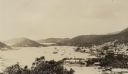
| Date: | 03 1913 |
|---|---|
| Description: | Elevated view of the harbor at Charlotte Amalie, St. Thomas. Sailing vessels of various sizes are moored in the harbor. There are islands in the background... |

| Date: | 1864 |
|---|---|
| Description: | A map of Sherman's March from Atlanta, Georgia to Goldsboro, North Carolina. |

| Date: | 1867 |
|---|---|
| Description: | A map and profile map of the railroad line from Omaha to San Francisco. |
If you didn't find the material you searched for, our Library Reference Staff can help.
Call our reference desk at 608-264-6535 or email us at: