 Filter: Categories of Wisconsin Historical Images
Filter: Subject of Ocean
Filter: Subject of cities and towns
Filter: Subject of intellectual life
Filter: Categories of Wisconsin Historical Images
Filter: Subject of Ocean
Filter: Subject of cities and towns
Filter: Subject of intellectual life

| Date: | 1939 |
|---|---|
| Description: | Aerial view of International Harvester's Geelong Works in Geelong, Victoria, Australia. |

| Date: | |
|---|---|
| Description: | Aerial view of a developed strip of land on Barnegat Bay showing the Atlantic ocean, houses, lakes, railroad tracks, a marina and a jetty in the distance. |

| Date: | 10 23 1945 |
|---|---|
| Description: | Aerial view of U.S.S. Wisconsin (BB-64) in San Francisco Bay. Several boats can be seen in the water near the ship and San Francisco is visible in t... |

| Date: | 1959 |
|---|---|
| Description: | Aerial view of the island of Cuba taken from a small plane. Part of the plane with a Cuban flag painted on it is in the frame, and the island with many bui... |

| Date: | 1932 |
|---|---|
| Description: | Map of the Middle East accompanying an article on International's involvement in building the Iraq Pipe Line. Headline text on the page reads: "Internation... |

| Date: | 1918 |
|---|---|
| Description: | United States government bonds poster in the Fourth Liberty Loan "B" series. "Buy Liberty Bonds. Fourth Liberty Loan." Depicts enemy aircraft bombing New Y... |

| Date: | 03 24 1950 |
|---|---|
| Description: | Front cover of a farewell dinner menu from the Italian Line ship Saturnia, with two Commedia dell' Arte characters: Tartaglia, a rotund figure who w... |

| Date: | |
|---|---|
| Description: | Letterhead of Johnson & Melaas, merchant tailors and cloth dealers, "Buyers of wool and Wisconsin leaf tobacco," with an engraving of a waterfront view of ... |
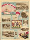
| Date: | 11 23 1930 |
|---|---|
| Description: | Full page illustrated article in the Milwaukee Journal titled "The World Voyagers go Round The Globe by Radio and Roto." Included are photographs an... |

| Date: | 1946 |
|---|---|
| Description: | This bird's-eye-view map shows scenes of land use and farming superimposed on a map of the United States. Agricultural scenes of farming, livestock, and cr... |

| Date: | 1715 |
|---|---|
| Description: | A map of the countries and islands surrounding the Gulf of Mexico. The hand-colored borders separate the territories of England, France, Spain, and Holland... |

| Date: | 1721 |
|---|---|
| Description: | A map of North and South America with an elaborately illustrated cartouche depicting Native Americans in upper left corner. The map is fairly detailed, dep... |

| Date: | 1735 |
|---|---|
| Description: | A map of the western hemisphere, including parts of western Europe and Africa. Portraits of explorers, such as Jacques Marquette, Louis Joliet, and Robert ... |

| Date: | 1739 |
|---|---|
| Description: | This map shows the territorial claims of the western hemisphere by the European powers, as well as the names of major cities, geographical features, and pa... |

| Date: | 1786 |
|---|---|
| Description: | This map is an updated version of d'Anville's 1761 map of the western hemisphere. He included more details to the north west coast of North America, partic... |

| Date: | 1703 |
|---|---|
| Description: | Map of the Golf of Mexico and surrounding countries from the Great Lakes down to the northern most parts of South America. L'Isle labels cities, towns, and... |

| Date: | 1720 |
|---|---|
| Description: | One of Herman Moll's most famous maps, often referred to as The Beaver Map for its elaborate engraved inset depicting and describing beavers building a dam... |

| Date: | 1715 |
|---|---|
| Description: | One of Herman Moll's most famous maps, often referred to as The Codfish Map, it shows rivers and portages, cities, Indian villages, wind directions, routes... |

| Date: | 1719 |
|---|---|
| Description: | Map of the British colonies and territories in North American, depicting cities, Native American land, rivers, mines, forts, trees, and topography east of ... |

| Date: | 1720 |
|---|---|
| Description: | This map of North America shows cities, rivers, lakes, and a few topographical features, complete with numerous descriptive blocks of text about expedition... |
If you didn't find the material you searched for, our Library Reference Staff can help.
Call our reference desk at 608-264-6535 or email us at: